Carte topographique Dayhoit
Cliquez sur la carte pour afficher l’altitude.
À propos de cette carte
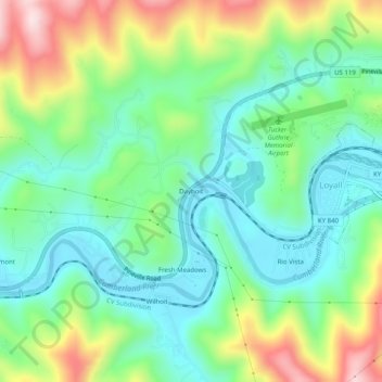
Nom : Carte topographique Dayhoit, altitude, relief.
Lieu : Dayhoit, Harlan County, Kentucky, 40824, United States (36.83138 -83.39237 36.87138 -83.35237)
Altitude moyenne : 462 m
Altitude minimum : 343 m
Altitude maximum : 710 m
Autres cartes topographiques
Cliquez sur une carte pour visualiser sa topographie, son altitude et son relief.
Cumberland
United States > Kentucky > Harlan County
Cumberland is located in northeastern Harlan County at 36°58′37″N 82°59′15″W / 36.97694°N 82.98750°W / 36.97694; -82.98750 (36.977016, -82.987434) in the valley of the Poor Fork of the Cumberland River, where it is joined by Looney Creek from the southeast and Cloverlick Creek from the…
Altitude moyenne : 591 m
Harlan
United States > Kentucky > Harlan County
Harlan is located in west-central Harlan County at 36°50′29″N 83°19′12″W / 36.84139°N 83.32000°W / 36.84139; -83.32000 (36.841487, -83.320066), at the junction of the Clover Fork and Martin's Fork rivers. The Clover Fork continues north 1.5 miles (2.4 km) to join the Poor Fork, forming the…
Altitude moyenne : 493 m
Lynch
United States > Kentucky > Harlan County
Lynch is located in eastern Harlan County at 36°57′54″N 82°55′00″W / 36.965133°N 82.916569°W / 36.965133; -82.916569 (36.965133, -82.916569), in the valley of Looney Creek. Lynch is the nearest city to Kentucky's highest point, Black Mountain (4,145 ft or 1,263 m). Sitting at an elevation…
Altitude moyenne : 770 m