
Carte topographique Bella Vista
Carte interactive
Cliquez sur la carte pour afficher l’altitude.
À propos de cette carte
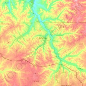
Nom : Carte topographique Bella Vista, altitude, relief.
Lieu : Bella Vista, Benton County, Arkansas, 72715, United States (36.41540 -94.37568 36.49960 -94.16197)
Altitude moyenne : 372 m
Altitude minimum : 283 m
Altitude maximum : 447 m
The city of Bella Vista is located on the Springfield Plateau of the Ozark Mountains. Oak/hickory forests, along with valleys, creeks, and steep rises, characterize the city's topography. Bella Vista is located north of Bentonville and Rogers within the Northwest Arkansas region. The city has been experiencing a population and building boom in recent years, as indicated by a 60% growth in population between the 2000 and 2010 censuses.
Autres cartes topographiques
Cliquez sur une carte pour visualiser sa topographie, son altitude et son relief.
Rogers
United States > Arkansas > Benton County
Rogers, Benton County, Arkansas, United States
Altitude moyenne : 393 m
Bentonville
United States > Arkansas > Benton County
Bentonville, Benton County, Arkansas, United States
Altitude moyenne : 387 m
Beaver Lake
United States > Arkansas > Benton County > Goshen
Beaver Lake, Goshen, Benton County, Arkansas, 72757, United States
Altitude moyenne : 394 m
Lost Bridge Village
United States > Arkansas > Benton County
Lost Bridge Village, Benton County, Arkansas, United States
Altitude moyenne : 377 m
Little Flock
United States > Arkansas > Benton County
Little Flock, Benton County, Arkansas, United States
Altitude moyenne : 388 m
Maysville
United States > Arkansas > Benton County
Maysville, Benton County, Arkansas, 72747, United States
Altitude moyenne : 323 m
Decatur
United States > Arkansas > Benton County
Decatur, Benton County, Arkansas, 72722, United States
Altitude moyenne : 379 m
Gateway
United States > Arkansas > Benton County
Gateway, Benton County, Arkansas, 72733, United States
Altitude moyenne : 467 m
Springtown
United States > Arkansas > Benton County
Springtown, Benton County, Arkansas, 72734, United States
Altitude moyenne : 388 m
Siloam Springs
United States > Arkansas > Benton County
Siloam Springs, Benton County, Arkansas, 72761, United States
Altitude moyenne : 339 m
Hiwasse
United States > Arkansas > Benton County > Gravette
Hiwasse, Gravette, Benton County, Arkansas, 72739, United States
Altitude moyenne : 394 m
Benton Country Fair Grounds
United States > Arkansas > Benton County > Bentonville
Benton Country Fair Grounds, Bentonville, Benton County, Arkansas, United States
Altitude moyenne : 384 m
Lake Avalon
United States > Arkansas > Benton County > Bella Vista
Lake Avalon, Bella Vista, Benton County, Arkansas, 72715, United States
Altitude moyenne : 353 m
Rago
United States > Arkansas > Benton County > Bella Vista
Rago, Bella Vista, Benton County, Arkansas, 72715, United States
Altitude moyenne : 378 m
Loch Lomond
United States > Arkansas > Benton County > Bella Vista
Loch Lomond, Bella Vista, Benton County, Arkansas, 72715, United States
Altitude moyenne : 360 m
Dug Hill
United States > Arkansas > Benton County > Bella Vista
Dug Hill, Bella Vista, Benton County, Arkansas, 72715, United States
Altitude moyenne : 344 m
Centerton
United States > Arkansas > Benton County
Centerton, Benton County, Arkansas, 72719, United States
Altitude moyenne : 393 m
Pedro
United States > Arkansas > Benton County
Pedro, Benton County, Arkansas, United States
Altitude moyenne : 334 m
Lake Windsor
United States > Arkansas > Benton County > Bella Vista
Lake Windsor, Bella Vista, Benton County, Arkansas, 72715, United States
Altitude moyenne : 352 m
Silent Grove
United States > Arkansas > Benton County > Springdale
Silent Grove, Springdale, Benton County, Arkansas, 72762, United States
Altitude moyenne : 394 m
Cave Springs
United States > Arkansas > Benton County
Cave Springs, Benton County, Arkansas, 72718, United States
Altitude moyenne : 375 m
Gravette
United States > Arkansas > Benton County
Gravette, Benton County, Arkansas, United States
Altitude moyenne : 356 m
Siloam Springs Lake
United States > Arkansas > Benton County > Siloam Springs
Siloam Springs Lake, Siloam Springs, Benton County, Arkansas, United States
Altitude moyenne : 341 m
Healing Springs
United States > Arkansas > Benton County
Healing Springs, Benton County, Arkansas, United States
Altitude moyenne : 365 m
Garfield
United States > Arkansas > Benton County
Garfield, Benton County, Arkansas, 72732, United States
Altitude moyenne : 453 m
Oak Grove
United States > Arkansas > Benton County > Oak Grove
Oak Grove, Benton County, Arkansas, 72757, United States
Altitude moyenne : 362 m
Lake Springdale
United States > Arkansas > Benton County > Springdale
Lake Springdale, Springdale, Benton County, Arkansas, United States
Altitude moyenne : 392 m
Lowell
United States > Arkansas > Benton County
Lowell, Benton County, Arkansas, United States
Altitude moyenne : 404 m
Sulphur Springs
United States > Arkansas > Benton County
Sulphur Springs, Benton County, Arkansas, United States
Altitude moyenne : 308 m
Gentry
United States > Arkansas > Benton County
Gentry, Benton County, Arkansas, 72734, United States
Altitude moyenne : 371 m
Bella Vista
United States > Arkansas > Benton County > Bella Vista > Bella Vista
Bella Vista, Benton County, Arkansas, 72715, United States
Altitude moyenne : 359 m
Garfield
United States > Arkansas > Benton County > Garfield
Garfield, Benton County, Arkansas, 72732, United States
Altitude moyenne : 453 m
Pea Ridge
United States > Arkansas > Benton County
Pea Ridge, Benton County, Arkansas, 72751, United States
Altitude moyenne : 393 m