
Carte topographique Lake Windsor
Carte interactive
Cliquez sur la carte pour afficher l’altitude.
À propos de cette carte
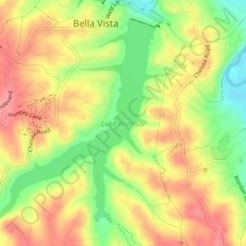
Nom : Carte topographique Lake Windsor, altitude, relief.
Altitude moyenne : 352 m
Altitude minimum : 302 m
Altitude maximum : 391 m
Autres cartes topographiques
Cliquez sur une carte pour visualiser sa topographie, son altitude et son relief.
Lake Avalon
United States > Arkansas > Benton County > Bella Vista
Lake Avalon, Bella Vista, Benton County, Arkansas, 72715, United States
Altitude moyenne : 353 m
Rago
United States > Arkansas > Benton County > Bella Vista
Rago, Bella Vista, Benton County, Arkansas, 72715, United States
Altitude moyenne : 378 m
Loch Lomond
United States > Arkansas > Benton County > Bella Vista
Loch Lomond, Bella Vista, Benton County, Arkansas, 72715, United States
Altitude moyenne : 360 m
Dug Hill
United States > Arkansas > Benton County > Bella Vista
Dug Hill, Bella Vista, Benton County, Arkansas, 72715, United States
Altitude moyenne : 344 m
Bella Vista
United States > Arkansas > Benton County > Bella Vista > Bella Vista
Bella Vista, Benton County, Arkansas, 72715, United States
Altitude moyenne : 359 m