
Carte topographique Flagler County
Carte interactive
Cliquez sur la carte pour afficher l’altitude.
À propos de cette carte
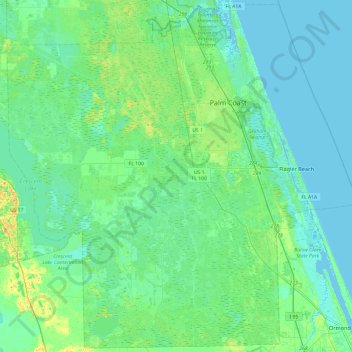
Nom : Carte topographique Flagler County, altitude, relief.
Lieu : Flagler County, Florida, United States (29.26113 -81.52366 29.67109 -81.04192)
Altitude moyenne : 6 m
Altitude minimum : -4 m
Altitude maximum : 28 m
Autres cartes topographiques
Cliquez sur une carte pour visualiser sa topographie, son altitude et son relief.
Florida Keys
United States > Florida > Monroe County
The Florida Keys, an archipelago extending about 120 miles from the southeastern tip of Florida, feature a unique topography characterized by low-lying coral islands and a series of intricate waterways. Most islands are less than 5 feet above sea level, contributing to their vulnerability to storm surges and…
Altitude moyenne : 0 m
Hudson
United States > Florida > Hudson
Hudson features a predominantly flat and low-lying topography typical of the region, with an average elevation of approximately 16 feet above sea level. This terrain is interspersed with various wetlands and small lakes, creating a rich ecosystem that supports diverse wildlife. The area also includes a few…
Altitude moyenne : 5 m
Largo
United States > Florida > Pinellas County > Largo
In 2010, Largo's total area was 18.6 square miles (48.1 km2), of which 17.6 square miles (45.6 km2) was land and 0.97 square miles (2.5 km2), or 5.22%, was water. As of 2004, there were 651 acres (2.6 km2) of park lands. The city's lowest elevation is sea level. At its highest, the city's elevation is about 69…
Altitude moyenne : 5 m
Key Biscayne
United States > Florida > Miami-Dade County
Key Biscayne lies south of Miami Beach and east of Miami. The village is connected to Miami via the Rickenbacker Causeway, originally built in 1947. Because of its low elevation and direct exposure to the Atlantic Ocean, it is usually among the first Miami areas to be evacuated before an oncoming hurricane.
Altitude moyenne : 3 m
Punta Gorda
United States > Florida > Charlotte County > Punta Gorda > Punta Gorda
Altitude moyenne : 2 m
City of Tampa Waterworks Dam
United States > Florida > Hillsborough County > Tampa > Altos Verdes
Altitude moyenne : 13 m
Gulf Gate Estates
United States > Florida > Sarasota County > Gulf Gate Estates
Altitude moyenne : 7 m
Choctaw Beach Community Center Park
United States > Florida > Walton County > Freeport > Choctaw Beach
Altitude moyenne : 7 m
Vermont Heights
United States > Florida > Saint Johns County
Vermont Heights is located at 29°48′36″N 81°23′50″W / 29.81°N 81.3972°W / 29.81; -81.3972 (29.81, -81.3972) Elevation of 46 Feet. Vermont Heights is the location of the Coquina Crossing Mobile Home Park and St. Augustine Community School of Performing Arts, both of which give their…
Altitude moyenne : 13 m
Myakka City
United States > Florida > Manatee County
Myakka City (also Myakka) is an unincorporated community in southeastern Manatee County, Florida, United States. It lies along State Road 70 near the city of Bradenton, the county seat of Manatee County. Its elevation is 43 feet (13 m), and it is located at 27°20′59″N 82°9′41″W / 27.34972°N…
Altitude moyenne : 14 m