
Carte topographique Sanibel Island
Carte interactive
Cliquez sur la carte pour afficher l’altitude.
À propos de cette carte
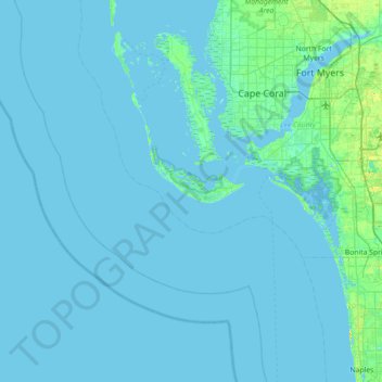
Nom : Carte topographique Sanibel Island, altitude, relief.
Altitude moyenne : 1 m
Altitude minimum : -1 m
Altitude maximum : 21 m
Autres cartes topographiques
Cliquez sur une carte pour visualiser sa topographie, son altitude et son relief.
Wulfert
United States > Florida > Lee County > Sanibel
Wulfert, Sanibel, Lee County, Florida, 33926, United States
Altitude moyenne : 1 m
Ybel
United States > Florida > Lee County > Sanibel
Ybel, Sanibel, Lee County, Florida, 33957, United States
Altitude moyenne : 2 m