
Carte topographique Emmaus
Carte interactive
Cliquez sur la carte pour afficher l’altitude.
Emmaus
According to the U.S. Census Bureau, the borough has a total area of 2.9 square miles (7.5 km2), all land, though part of Little Lehigh Creek, a tributary of the Lehigh River, flows just outside the Emmaus border with Salisbury Township. Emmaus borders South Mountain, a large Appalachian mountain range. The town's elevation is 436 feet above sea level. Emmaus is located at approximately 40°32′13″N 75°29′45″W / 40.53694°N 75.49583°W / 40.53694; -75.49583. It has a hot-summer humid continental climate (Dfa) and is in hardiness zone 6b. Average monthly temperatures in the downtown vicinity range from 28.9 °F in January to 73.5 °F in July.
À propos de cette carte
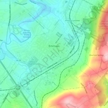
Nom : Carte topographique Emmaus, altitude, relief.
Lieu : Emmaus, Lehigh County, Pennsylvania, 18049, United States (40.51674 -75.52038 40.55645 -75.47900)
Altitude moyenne : 154 m
Altitude minimum : 89 m
Altitude maximum : 296 m
Autres cartes topographiques
Cliquez sur une carte pour visualiser sa topographie, son altitude et son relief.
Walbert
United States > Pennsylvania > Lehigh County > South Whitehall Township
Altitude moyenne : 137 m
Fogelsville
United States > Pennsylvania > Lehigh County > Upper Macungie Township
Altitude moyenne : 155 m
Hensingersville
United States > Pennsylvania > Lehigh County > Lower Macungie Township
Altitude moyenne : 203 m
Bake Oven Knob
United States > Pennsylvania > Lehigh County > Heidelberg Township
Altitude moyenne : 310 m
Laurys Station
United States > Pennsylvania > Lehigh County > North Whitehall Township
Altitude moyenne : 152 m
Neffs
United States > Pennsylvania > Lehigh County > North Whitehall Township
Altitude moyenne : 208 m
Milford Park
United States > Pennsylvania > Lehigh County > Upper Milford Township
Altitude moyenne : 221 m
Old Zionsville
United States > Pennsylvania > Lehigh County > Upper Milford Township
Altitude moyenne : 217 m
Crackersport
United States > Pennsylvania > Lehigh County > South Whitehall Township
Altitude moyenne : 138 m
Metamora Station
United States > Pennsylvania > Lehigh County > South Whitehall Township > Metamora Station
Altitude moyenne : 125 m