
Carte topographique Louisville
Carte interactive
Cliquez sur la carte pour afficher l’altitude.
À propos de cette carte
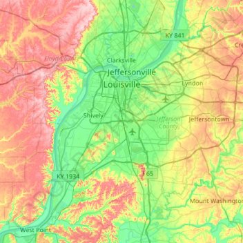
Nom : Carte topographique Louisville, altitude, relief.
Lieu : Louisville, Jefferson County, Kentucky, United States (37.99710 -85.94706 38.38014 -85.40510)
Altitude moyenne : 188 m
Altitude minimum : 114 m
Altitude maximum : 306 m
Throughout January 1937, 19.17 inches (48.7 cm) of rain fell in Louisville, and by January 27, the Ohio River crested at a record 57.15 feet (17.42 m), almost 30 feet (9.1 m) above flood stage. These events triggered the "Great Flood of 1937", which lasted into early February. The flood submerged 60–70 percent of the city, caused complete loss of power for four days, and forced the evacuation of 175,000 or 230,000 residents, depending on sources. Ninety people died as a result of the flood. It led to dramatic changes in where residents lived. Today, the city is protected by numerous flood walls. After the flood, the areas of high elevation in the eastern part of the city had decades of residential growth.
Autres cartes topographiques
Cliquez sur une carte pour visualiser sa topographie, son altitude et son relief.
Shawneeland
United States > Kentucky > Jefferson County > Louisville
Shawneeland, Louisville, Jefferson County, Kentucky, 40211, United States
Altitude moyenne : 138 m
Shively
United States > Kentucky > Jefferson County
Shively, Jefferson County, Kentucky, United States
Altitude moyenne : 141 m
Waverly Hills
United States > Kentucky > Jefferson County > Louisville
Waverly Hills, Louisville, Jefferson County, Kentucky, 40258, United States
Altitude moyenne : 155 m
Worthington Hills
United States > Kentucky > Jefferson County
Worthington Hills, Jefferson County, Kentucky, United States
Altitude moyenne : 221 m
Spring Mill
United States > Kentucky > Jefferson County
Spring Mill, Jefferson County, Kentucky, United States
Altitude moyenne : 195 m
Cherokee Park
United States > Kentucky > Jefferson County > Louisville
Cherokee Park, Louisville, Jefferson County, Kentucky, United States
Altitude moyenne : 159 m
Strathmoor Manor
United States > Kentucky > Jefferson County
Strathmoor Manor, Jefferson County, Kentucky, United States
Altitude moyenne : 161 m
Parkland
United States > Kentucky > Jefferson County > Louisville
Parkland, Louisville, Jefferson County, Kentucky, 40211, United States
Altitude moyenne : 139 m
Saint Matthews
United States > Kentucky > Jefferson County > Louisville
Saint Matthews, Louisville, Jefferson County, Kentucky, 40207, United States
Altitude moyenne : 166 m
Cherokee Garden
United States > Kentucky > Jefferson County > Louisville
Cherokee Garden, Louisville, Jefferson County, Kentucky, 40041, United States
Altitude moyenne : 164 m
Briarwood
United States > Kentucky > Jefferson County
Briarwood, Jefferson County, Kentucky, 40242, United States
Altitude moyenne : 189 m
Newburg
United States > Kentucky > Jefferson County > Louisville
Newburg, Louisville, Jefferson County, Kentucky, 40225, United States
Altitude moyenne : 156 m
West Buechel
United States > Kentucky > Jefferson County
West Buechel, Jefferson County, Kentucky, United States
Altitude moyenne : 150 m
Louisville-Jefferson County (Balance)
United States > Kentucky > Jefferson County > Louisville
Louisville-Jefferson County (Balance), Louisville, Jefferson County, Kentucky, 40231, United States
Altitude moyenne : 157 m
Lyndon
United States > Kentucky > Jefferson County
Lyndon, Jefferson County, Kentucky, 40222, United States
Altitude moyenne : 182 m
Druid Hills
United States > Kentucky > Jefferson County
Druid Hills, Jefferson County, Kentucky, United States
Altitude moyenne : 169 m
South Park
United States > Kentucky > Jefferson County > Louisville
South Park, Louisville, Jefferson County, Kentucky, 40118, United States
Altitude moyenne : 149 m
Audubon Park
United States > Kentucky > Jefferson County > Audubon Park
Audubon Park, Jefferson County, Kentucky, United States
Altitude moyenne : 155 m
Mirror Lakes
United States > Kentucky > Jefferson County > Louisville > Hopewell
Mirror Lakes, Hopewell, Louisville, Jefferson County, Kentucky, United States
Altitude moyenne : 198 m
Anchorage
United States > Kentucky > Jefferson County > Anchorage
Anchorage, Jefferson County, Kentucky, United States
Altitude moyenne : 219 m
Falls of the Ohio State Park
United States > Kentucky > Jefferson County > Louisville
Falls of the Ohio State Park, Louisville, Jefferson County, Kentucky, United States
Altitude moyenne : 135 m
Bellewood
United States > Kentucky > Jefferson County > St. Matthews > Bellewood
Bellewood, St. Matthews, Jefferson County, Kentucky, 40041, United States
Altitude moyenne : 167 m
Meadow Vale
United States > Kentucky > Jefferson County > Meadow Vale
Meadow Vale, Jefferson County, Kentucky, United States
Altitude moyenne : 201 m
Fern Creek
United States > Kentucky > Jefferson County > Louisville
Fern Creek, Louisville, Jefferson County, Kentucky, 40291, United States
Altitude moyenne : 211 m
Jeffersontown
United States > Kentucky > Jefferson County
Jeffersontown, Jefferson County, Kentucky, 40299, United States
Altitude moyenne : 207 m
Indian Hills
United States > Kentucky > Jefferson County
Indian Hills, Jefferson County, Kentucky, United States
Altitude moyenne : 161 m
Prospect
United States > Kentucky > Jefferson County
Prospect, Jefferson County, Kentucky, United States
Altitude moyenne : 166 m
Glenview
United States > Kentucky > Jefferson County
Glenview, Jefferson County, Kentucky, 40025, United States
Altitude moyenne : 155 m
Fincastle
United States > Kentucky > Jefferson County
Fincastle, Jefferson County, Kentucky, United States
Altitude moyenne : 218 m
St. Matthews
United States > Kentucky > Jefferson County
St. Matthews, Jefferson County, Kentucky, 40207, United States
Altitude moyenne : 167 m
Bethany
United States > Kentucky > Jefferson County > Louisville
Bethany, Louisville, Jefferson County, Kentucky, 40272, United States
Altitude moyenne : 141 m
Forest Hills
United States > Kentucky > Jefferson County
Forest Hills, Jefferson County, Kentucky, United States
Altitude moyenne : 202 m
Coldstream
United States > Kentucky > Jefferson County
Coldstream, Jefferson County, Kentucky, United States
Altitude moyenne : 219 m
Fairdale
United States > Kentucky > Jefferson County > Louisville
Fairdale, Louisville, Jefferson County, Kentucky, 40118, United States
Altitude moyenne : 158 m