
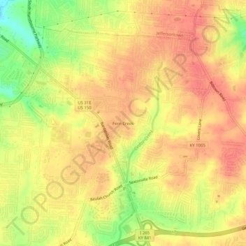
Carte topographique Fern Creek
Carte interactive
Cliquez sur la carte pour afficher l’altitude.
À propos de cette carte
Nom : Carte topographique Fern Creek, altitude, relief.
Altitude moyenne : 211 m
Altitude minimum : 173 m
Altitude maximum : 229 m
Autres cartes topographiques
Cliquez sur une carte pour visualiser sa topographie, son altitude et son relief.
Shawneeland
United States > Kentucky > Jefferson County > Louisville
Shawneeland, Louisville, Jefferson County, Kentucky, 40211, United States
Altitude moyenne : 138 m
Waverly Hills
United States > Kentucky > Jefferson County > Louisville
Waverly Hills, Louisville, Jefferson County, Kentucky, 40258, United States
Altitude moyenne : 155 m
Cherokee Park
United States > Kentucky > Jefferson County > Louisville
Cherokee Park, Louisville, Jefferson County, Kentucky, United States
Altitude moyenne : 159 m
Parkland
United States > Kentucky > Jefferson County > Louisville
Parkland, Louisville, Jefferson County, Kentucky, 40211, United States
Altitude moyenne : 139 m
Saint Matthews
United States > Kentucky > Jefferson County > Louisville
Saint Matthews, Louisville, Jefferson County, Kentucky, 40207, United States
Altitude moyenne : 166 m
Cherokee Garden
United States > Kentucky > Jefferson County > Louisville
Cherokee Garden, Louisville, Jefferson County, Kentucky, 40041, United States
Altitude moyenne : 164 m
Newburg
United States > Kentucky > Jefferson County > Louisville
Newburg, Louisville, Jefferson County, Kentucky, 40225, United States
Altitude moyenne : 156 m
Louisville-Jefferson County (Balance)
United States > Kentucky > Jefferson County > Louisville
Louisville-Jefferson County (Balance), Louisville, Jefferson County, Kentucky, 40231, United States
Altitude moyenne : 157 m
South Park
United States > Kentucky > Jefferson County > Louisville
South Park, Louisville, Jefferson County, Kentucky, 40118, United States
Altitude moyenne : 149 m
Mirror Lakes
United States > Kentucky > Jefferson County > Louisville > Hopewell
Mirror Lakes, Hopewell, Louisville, Jefferson County, Kentucky, United States
Altitude moyenne : 198 m
Falls of the Ohio State Park
United States > Kentucky > Jefferson County > Louisville
Falls of the Ohio State Park, Louisville, Jefferson County, Kentucky, United States
Altitude moyenne : 135 m
Bethany
United States > Kentucky > Jefferson County > Louisville
Bethany, Louisville, Jefferson County, Kentucky, 40272, United States
Altitude moyenne : 141 m
Fairdale
United States > Kentucky > Jefferson County > Louisville
Fairdale, Louisville, Jefferson County, Kentucky, 40118, United States
Altitude moyenne : 158 m