
Carte topographique Saguaro National Park
Carte interactive
Cliquez sur la carte pour afficher l’altitude.
Saguaro National Park
Both districts conserve tracts of the Sonoran Desert, including ranges of significant hills, the Tucson Mountains in the west and the Rincon Mountains in the east. Elevations in the Tucson Mountain District range from 2,180 to 4,687 feet (664 to 1,429 m), the summit of Wasson Peak. Elevations within the Rincon Mountain District vary from 2,670 to 8,666 feet (814 to 2,641 m) at the summit of Mica Mountain.
À propos de cette carte
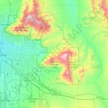
Nom : Carte topographique Saguaro National Park, altitude, relief.
Lieu : Saguaro National Park, Pima County, Arizona, United States (32.10403 -111.24383 32.35206 -110.49850)
Altitude moyenne : 1’174 m
Altitude minimum : 699 m
Altitude maximum : 2’784 m
Autres cartes topographiques
Cliquez sur une carte pour visualiser sa topographie, son altitude et son relief.
Tucson
United States > Arizona > Pima County > Tucson
The city's elevation is 2,643 ft (806 m) above sea level (as measured at the Tucson International Airport). Tucson is on an alluvial plain in the Sonoran Desert, surrounded by five minor ranges of mountains: the Santa Catalina Mountains and the Tortolita Mountains to the north, the Santa Rita Mountains to the…
Altitude moyenne : 836 m
Sonoran Desert
United States > Arizona > Pima County
To the north in California and northwest Arizona, the Sonoran Desert transitions to the colder-winter, higher-elevation Mojave, Great Basin, and Colorado Plateau deserts.
Altitude moyenne : 517 m
Pusch Ridge
United States > Arizona > Pima County
Pusch Ridge is primarily made up of three distinct peaks, including (from southwest to northeast in orientation) Pusch Peak, Bighorn Mountain, and Table Mountain. Pusch Peak is the westernmost point in the Santa Catalina Mountains, and rises in elevation over 2,000 feet (610 m) to a peak elevation of 5,366…
Altitude moyenne : 1’184 m