
Faire un don
Équipez-vous pour votre prochaine aventure :
En tant que Partenaire Amazon, ce site perçoit une commission sur les achats éligibles sans surcoût pour vous.
Carte topographique Mount Lemmon
Cliquez sur la carte pour afficher l’altitude.
Faire un don
Équipez-vous pour votre prochaine aventure :
En tant que Partenaire Amazon, ce site perçoit une commission sur les achats éligibles sans surcoût pour vous.
À propos de cette carte
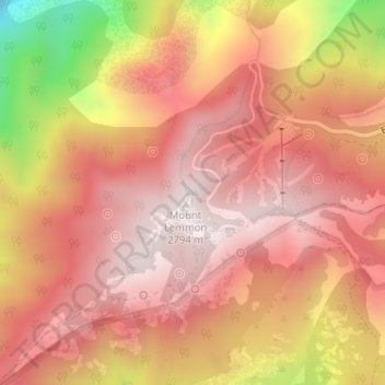
Nom : Carte topographique Mount Lemmon, altitude, relief.
Lieu : Mount Lemmon, Pima County, Arizona, 85619, United States (32.44262 -110.78884 32.44272 -110.78874)
Altitude moyenne : 2’515 m
Altitude minimum : 1’910 m
Altitude maximum : 2’789 m
Faire un don
Équipez-vous pour votre prochaine aventure :
En tant que Partenaire Amazon, ce site perçoit une commission sur les achats éligibles sans surcoût pour vous.
Autres cartes topographiques
Cliquez sur une carte pour visualiser sa topographie, son altitude et son relief.
Pusch Ridge
United States > Arizona > Pima County
Pusch Ridge is primarily made up of three distinct peaks, including (from southwest to northeast in orientation) Pusch Peak, Bighorn Mountain, and Table Mountain. Pusch Peak is the westernmost point in the Santa Catalina Mountains, and rises in elevation over 2,000 feet (610 m) to a peak elevation of 5,366…
Altitude moyenne : 1’184 m
Drexel Heights
United States > Arizona > Pima County > Tucson
The area has numerous Saguaro cacti, and is positioned only a couple of miles south of the Saguaro National Park. The northern boundary of Drexel Heights is the Tucson Mountain Park. It is cut off from the rest of Tucson due to the topography of the Tucson Mountains, which are only crossed via a small number…
Altitude moyenne : 786 m
Faire un don
Équipez-vous pour votre prochaine aventure :
En tant que Partenaire Amazon, ce site perçoit une commission sur les achats éligibles sans surcoût pour vous.
Faire un don
Équipez-vous pour votre prochaine aventure :
En tant que Partenaire Amazon, ce site perçoit une commission sur les achats éligibles sans surcoût pour vous.
Faire un don
Équipez-vous pour votre prochaine aventure :
En tant que Partenaire Amazon, ce site perçoit une commission sur les achats éligibles sans surcoût pour vous.
Saguaro National Park - Tucson Mountain District
United States > Arizona > Pima County > Marana
Both districts conserve tracts of the Sonoran Desert, including ranges of significant hills, the Tucson Mountains in the west and the Rincon Mountains in the east. Elevations in the Tucson Mountain District range from 2,180 to 4,687 feet (664 to 1,429 m), the summit of Wasson Peak. Elevations within the Rincon…
Altitude moyenne : 794 m
Faire un don
Équipez-vous pour votre prochaine aventure :
En tant que Partenaire Amazon, ce site perçoit une commission sur les achats éligibles sans surcoût pour vous.
Faire un don
Équipez-vous pour votre prochaine aventure :
En tant que Partenaire Amazon, ce site perçoit une commission sur les achats éligibles sans surcoût pour vous.