
Carte topographique Bucks County
Cliquez sur la carte pour afficher l’altitude.
Bucks County
According to the Trewartha climate classification system, the Piedmont (United States) section of Bucks County, which is located roughly northwest of U.S. Route 1, has a Temperate Continental Climate with hot and slightly humid summers, cold winters and year-around precipitation (Dcao). Dcao climates are characterized by at least one month having an average mean temperature ≤ 32.0 °F (0 °C), four to seven months with an average mean temperature ≥ 50.0 °F (10 °C), at least one month with an average mean temperature ≥ 72.0 °F (22 °C) and no significant precipitation difference between seasons. According to the Köppen climate classification system, the climate is a hot-summer, wet all year, humid continental climate (Dfa). During the summer months in the Piedmont, episodes of extreme heat and humidity can occur with heat index values > 102 °F (39 °C). The average wettest month is July which corresponds with the annual peak in thunderstorm activity. During the winter months, episodes of extreme cold and wind can occur with wind chill values < −16 °F (−27 °C). The plant hardiness zone at Haycock Mountain, elevation 968 ft (295 m), is 6b with an average annual extreme minimum air temperature of −4.6 °F (−20 °C). The average seasonal (Nov-Apr) snowfall total is between 26 and 36 inches (66 and 91 cm) depending on elevation and distance from the Atlantic Ocean. The average snowiest month is February which correlates with the annual peak in nor'easter activity. Some areas of the Piedmont farther south and along the river below New Hope are in hardiness zone 7a, as is the Atlantic Coastal Plain region of Bucks.
À propos de cette carte
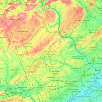
Nom : Carte topographique Bucks County, altitude, relief.
Lieu : Bucks County, Pennsylvania, United States (40.04980 -75.48393 40.60872 -74.72111)
Altitude moyenne : 98 m
Altitude minimum : -2 m
Altitude maximum : 312 m
Autres cartes topographiques
Cliquez sur une carte pour visualiser sa topographie, son altitude et son relief.
Fogelsville
United States > Pennsylvania > Lehigh County > Upper Macungie Township
Altitude moyenne : 155 m
East Texas
United States > Pennsylvania > Lehigh County > Lower Macungie Township
Altitude moyenne : 126 m
Penn Valley
United States > Pennsylvania > Montgomery County > Lower Merion Township > Ardmore
Altitude moyenne : 89 m
Faylor Lake
United States > Pennsylvania > Snyder County > Spring Township > Beaver Springs
Altitude moyenne : 197 m
Arnold City
United States > Pennsylvania > Fayette County > Washington Township
Altitude moyenne : 303 m
Hazelton Mills
United States > Pennsylvania > McKean County > Bradford Township
Altitude moyenne : 598 m
East Waterford
United States > Pennsylvania > Juniata County > Tuscarora Township
Altitude moyenne : 257 m
Breezewood
United States > Pennsylvania > Bedford County > East Providence Township
Altitude moyenne : 413 m
Plymouth Meeting
United States > Pennsylvania > Montgomery County > Whitemarsh Township > Harmonville
Altitude moyenne : 54 m
Glade Mills
United States > Pennsylvania > Butler County > Middlesex Township
Altitude moyenne : 359 m
Dingmans Ferry
United States > Pennsylvania > Pike County > Delaware Township
Altitude moyenne : 192 m
Mount Nebo Park
United States > Pennsylvania > Monroe County > East Stroudsburg > Twin Falls
Altitude moyenne : 185 m
Sinnemahoning
United States > Pennsylvania > Cameron County > Gibson Township
Altitude moyenne : 406 m
Saint Benedict
United States > Pennsylvania > Cambria County > West Carroll Township
Altitude moyenne : 582 m
Fort Hunter
United States > Pennsylvania > Dauphin County > Middle Paxton Township
Altitude moyenne : 149 m
Normalville
United States > Pennsylvania > Fayette County > Springfield Township
Altitude moyenne : 486 m
Three Tuns
United States > Pennsylvania > Montgomery County > Upper Dublin Township > Maple Glen
Altitude moyenne : 101 m
Hidden Valley
United States > Pennsylvania > Montgomery County > Upper Merion Township
Altitude moyenne : 47 m
Strafford
United States > Pennsylvania > Chester County > Tredyffrin Township
Altitude moyenne : 133 m
Reservoir Heights
United States > Pennsylvania > Dauphin County > Upper Paxton Township
Altitude moyenne : 189 m
Skytop
United States > Pennsylvania > Monroe County > Barrett Township
Skytop is an unincorporated community in Barrett Township, Monroe County, Pennsylvania, United States. Located north of Mountainhome, it is accessible by local roads off Route 390. Its elevation is 1,562 feet (476 m), and it is located at 41°13′40″N 75°14′18″W / 41.22778°N 75.23833°W /…
Altitude moyenne : 469 m
Ricketts Glen State Park
United States > Pennsylvania > Luzerne County > Fairmount Township
The state's original plans for the new park included building an inn, an 18-hole golf course and country club, and a winter sports complex for skiing, ice boating, and tobogganing, as well as a beach with bathing facilities, cabins, and a tent camping area. Only the last three were actually built, all south of…
Altitude moyenne : 588 m
Pendle Hill
United States > Pennsylvania > Delaware County > Nether Providence Township
Altitude moyenne : 61 m
Longwood Gardens
United States > Pennsylvania > Chester County > East Marlborough Township
Altitude moyenne : 125 m
Marble Hall
United States > Pennsylvania > Montgomery County > Whitemarsh Township
Altitude moyenne : 64 m
Chadds Ford Township
United States > Pennsylvania > Delaware County > Chadds Ford Township
Altitude moyenne : 101 m
Strawberry Mansion
United States > Pennsylvania > Philadelphia County > Philadelphia
Altitude moyenne : 31 m
Champion
United States > Pennsylvania > Allegheny County > North Fayette Township
Altitude moyenne : 360 m
Raven Rock Mountain
United States > Pennsylvania > Adams County > Liberty Township
Altitude moyenne : 312 m
Middlebury Center
United States > Pennsylvania > Tioga County > Middlebury Township
Altitude moyenne : 462 m
Donegal Lake
United States > Pennsylvania > Westmoreland County > Donegal Township
Altitude moyenne : 493 m
Centreville
United States > Pennsylvania > Lehigh County > Lower Macungie Township
Altitude moyenne : 144 m
Bass Lake
United States > Pennsylvania > York County > Newberry Township > Valley Green
Altitude moyenne : 143 m
Croydon Heights
United States > Pennsylvania > Bucks County > Bristol Township > Croydon
Altitude moyenne : 10 m
North Towanda
United States > Pennsylvania > Bradford County > North Towanda Township
Altitude moyenne : 286 m
Villanova
United States > Pennsylvania > Delaware County > Radnor Township > Radnor
Altitude moyenne : 119 m
Bessemer
United States > Pennsylvania > Westmoreland County > East Huntingdon Township
Altitude moyenne : 342 m
Holland Heights
United States > Pennsylvania > Lancaster County > East Lampeter Township
Altitude moyenne : 101 m
North Rochester
United States > Pennsylvania > Beaver County > Rochester Township
Altitude moyenne : 283 m
Wescosville
United States > Pennsylvania > Lehigh County > Lower Macungie Township
Altitude moyenne : 128 m
Bala Cynwyd
United States > Pennsylvania > Montgomery County > Lower Merion Township
Altitude moyenne : 76 m
Morrisdale
United States > Pennsylvania > Clearfield County > Morris Township
Altitude moyenne : 486 m
Glen Providence Park
United States > Pennsylvania > Delaware County > Upper Providence > Moylan
Altitude moyenne : 76 m
Waterville
United States > Pennsylvania > Lycoming County > Cummings Township
Altitude moyenne : 388 m
Albrightsville
United States > Pennsylvania > Carbon County > Kidder Township
Altitude moyenne : 498 m
Holiday Poconos
United States > Pennsylvania > Carbon County > Kidder Township
Altitude moyenne : 519 m
Garrett Hill
United States > Pennsylvania > Delaware County > Radnor Township > Radnor
Altitude moyenne : 117 m
Woodwards Corner
United States > Pennsylvania > Chester County > West Bradford Township
Altitude moyenne : 143 m