
Carte topographique Fort Hunter
Cliquez sur la carte pour afficher l’altitude.
À propos de cette carte
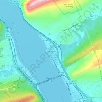
Nom : Carte topographique Fort Hunter, altitude, relief.
Altitude moyenne : 149 m
Altitude minimum : 91 m
Altitude maximum : 381 m
Autres cartes topographiques
Cliquez sur une carte pour visualiser sa topographie, son altitude et son relief.
Blue Mountain
United States > Pennsylvania > Dauphin County > Middle Paxton Township
The ridge of Blue Mountain runs for 150 miles (240 km) through Pennsylvania, reaching an elevation of 2,270 feet (690 m) above sea level just north of the Pennsylvania Turnpike, near the borough of Newburg. Most of the ridgecrest, however, only reaches between 1,400 and 1,700 feet (430 and 520 m) in elevation.…
Altitude moyenne : 199 m
Susquehanna River
United States > Pennsylvania > Dauphin County > Middle Paxton Township
Altitude moyenne : 118 m
Clark Creek
United States > Pennsylvania > Dauphin County > Middle Paxton Township
Altitude moyenne : 135 m