
Faire un don
Équipez-vous pour votre prochaine aventure :
En tant que Partenaire Amazon, ce site perçoit une commission sur les achats éligibles sans surcoût pour vous.
Carte topographique East Hertfordshire
Cliquez sur la carte pour afficher l’altitude.
Faire un don
Équipez-vous pour votre prochaine aventure :
En tant que Partenaire Amazon, ce site perçoit une commission sur les achats éligibles sans surcoût pour vous.
À propos de cette carte
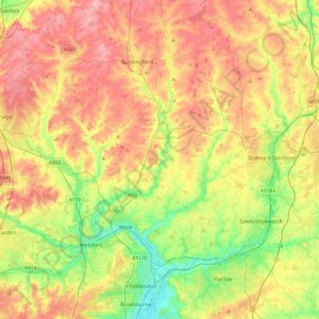
Nom : Carte topographique East Hertfordshire, altitude, relief.
Lieu : East Hertfordshire, Hertfordshire, England, United Kingdom (51.73423 -0.18361 51.99716 0.19557)
Altitude moyenne : 91 m
Altitude minimum : 23 m
Altitude maximum : 165 m
Faire un don
Équipez-vous pour votre prochaine aventure :
En tant que Partenaire Amazon, ce site perçoit une commission sur les achats éligibles sans surcoût pour vous.
Autres cartes topographiques
Cliquez sur une carte pour visualiser sa topographie, son altitude et son relief.
Faire un don
Équipez-vous pour votre prochaine aventure :
En tant que Partenaire Amazon, ce site perçoit une commission sur les achats éligibles sans surcoût pour vous.
Ivel Springs Local Nature Reserve
United Kingdom > England > Hertfordshire > North Hertfordshire > Baldock
Altitude moyenne : 72 m
Bushey
United Kingdom > England > Hertfordshire > Hertsmere
Bushey is a town in the Hertsmere borough of Hertfordshire in the East of England. It had a population of 25,328 in the 2011 census, rising to 28,416 in the 2021 census, an increase of 12.19%. This makes Bushey the second most populated town in Hertsmere. Bushey Heath is a large neighbourhood south east of…
Altitude moyenne : 88 m
St Albans
United Kingdom > England > Hertfordshire > St Albans
St Albans was an ancient borough created following the dissolution of the monastery in 1539. It consisted of the ancient parish of St Albans (also known as the Abbey parish) and parts of St Michael and St Peter. The municipal corporation was reformed by the Municipal Corporations Act 1835 and the boundary was…
Altitude moyenne : 100 m
Faire un don
Équipez-vous pour votre prochaine aventure :
En tant que Partenaire Amazon, ce site perçoit une commission sur les achats éligibles sans surcoût pour vous.
Bovingdon Green
United Kingdom > England > Hertfordshire > Dacorum > Bovingdon
Altitude moyenne : 151 m
Long Pond
United Kingdom > England > Hertfordshire > North Hertfordshire > Offley > Offley Hoo
Altitude moyenne : 142 m
Faire un don
Équipez-vous pour votre prochaine aventure :
En tant que Partenaire Amazon, ce site perçoit une commission sur les achats éligibles sans surcoût pour vous.
Broad Green
United Kingdom > England > Hertfordshire > East Hertfordshire > Bayford
Altitude moyenne : 73 m
Faire un don
Équipez-vous pour votre prochaine aventure :
En tant que Partenaire Amazon, ce site perçoit une commission sur les achats éligibles sans surcoût pour vous.
Letchworth
United Kingdom > England > Hertfordshire > North Hertfordshire > Letchworth
Altitude moyenne : 80 m
Faire un don
Équipez-vous pour votre prochaine aventure :
En tant que Partenaire Amazon, ce site perçoit une commission sur les achats éligibles sans surcoût pour vous.
Nettleden
United Kingdom > England > Hertfordshire > Dacorum > Great Gaddesden
Altitude moyenne : 149 m
Tyttenhanger
United Kingdom > England > Hertfordshire > St Albans > Colney Heath
Altitude moyenne : 83 m
Elstree
United Kingdom > England > Hertfordshire > Hertsmere
In 1723, topographer John Norden noted in his book Speculum Britanniae, that in the county of Hartfordshire [sic] was one "Elstre or Eglestre". In an earlier edition, he writes.
Altitude moyenne : 105 m
Faire un don
Équipez-vous pour votre prochaine aventure :
En tant que Partenaire Amazon, ce site perçoit une commission sur les achats éligibles sans surcoût pour vous.
Mardleybury
United Kingdom > England > Hertfordshire > Welwyn Hatfield > Woolmer Green
Altitude moyenne : 109 m
Crab's Green
United Kingdom > England > Hertfordshire > East Hertfordshire > Stocking Pelham
Altitude moyenne : 111 m
Faire un don
Équipez-vous pour votre prochaine aventure :
En tant que Partenaire Amazon, ce site perçoit une commission sur les achats éligibles sans surcoût pour vous.
Trowley Bottom
United Kingdom > England > Hertfordshire > Dacorum > Flamstead
Altitude moyenne : 139 m
Westbrook Mere
United Kingdom > England > Hertfordshire > Dacorum > Bourne End
Altitude moyenne : 125 m
Lower Gustard Wood
United Kingdom > England > Hertfordshire > St Albans > Wheathampstead
Altitude moyenne : 112 m
Faire un don
Équipez-vous pour votre prochaine aventure :
En tant que Partenaire Amazon, ce site perçoit une commission sur les achats éligibles sans surcoût pour vous.
Church End
United Kingdom > England > Hertfordshire > East Hertfordshire > Little Hadham
Altitude moyenne : 95 m
Bushey
United Kingdom > England > Hertfordshire > Hertsmere
Bushey is a town in the Hertsmere borough of Hertfordshire in the East of England. It had a population of 25,328 in the 2011 census, rising to 28,416 in the 2021 census, an increase of 12.19%. This makes Bushey the second most populated town in Hertsmere. Bushey Heath is a large neighbourhood south east of…
Altitude moyenne : 88 m
Ashbrook
United Kingdom > England > Hertfordshire > North Hertfordshire > St Ippolyts
Altitude moyenne : 85 m
Faire un don
Équipez-vous pour votre prochaine aventure :
En tant que Partenaire Amazon, ce site perçoit une commission sur les achats éligibles sans surcoût pour vous.
Knebworth Country Park
United Kingdom > England > Hertfordshire > North Hertfordshire > Knebworth
Altitude moyenne : 116 m
Faire un don
Équipez-vous pour votre prochaine aventure :
En tant que Partenaire Amazon, ce site perçoit une commission sur les achats éligibles sans surcoût pour vous.
Hertford Lock No 1
United Kingdom > England > Hertfordshire > East Hertfordshire > Hertford
Altitude moyenne : 53 m
Bentley Heath
United Kingdom > England > Hertfordshire > Hertsmere > Potters Bar
Altitude moyenne : 105 m
Faire un don
Équipez-vous pour votre prochaine aventure :
En tant que Partenaire Amazon, ce site perçoit une commission sur les achats éligibles sans surcoût pour vous.
Mill Green
United Kingdom > England > Hertfordshire > Welwyn Hatfield > Hatfield
Altitude moyenne : 81 m
Faire un don
Équipez-vous pour votre prochaine aventure :
En tant que Partenaire Amazon, ce site perçoit une commission sur les achats éligibles sans surcoût pour vous.
Elstree
United Kingdom > England > Hertfordshire > Hertsmere
In 1723, topographer John Norden noted in his book Speculum Britanniae, that in the county of Hartfordshire [sic] was one "Elstre or Eglestre". In an earlier edition, he writes.
Altitude moyenne : 105 m
Faire un don
Équipez-vous pour votre prochaine aventure :
En tant que Partenaire Amazon, ce site perçoit une commission sur les achats éligibles sans surcoût pour vous.
Patchetts Green
United Kingdom > England > Hertfordshire > Hertsmere > Aldenham
Altitude moyenne : 83 m
Sarratt Bottom
United Kingdom > England > Hertfordshire > Three Rivers > Sarratt
Altitude moyenne : 112 m
Stanborough Park
United Kingdom > England > Hertfordshire > Welwyn Hatfield > Hatfield > Stanborough
Altitude moyenne : 79 m
Faire un don
Équipez-vous pour votre prochaine aventure :
En tant que Partenaire Amazon, ce site perçoit une commission sur les achats éligibles sans surcoût pour vous.
Whempstead
United Kingdom > England > Hertfordshire > East Hertfordshire > Dane End
Altitude moyenne : 95 m
Pimlico
United Kingdom > England > Hertfordshire > Three Rivers > Abbots Langley
Altitude moyenne : 123 m
Faire un don
Équipez-vous pour votre prochaine aventure :
En tant que Partenaire Amazon, ce site perçoit une commission sur les achats éligibles sans surcoût pour vous.
Dixon's Gap Bridge
United Kingdom > England > Hertfordshire > Dacorum > Wilstone > Gubblecote
Altitude moyenne : 101 m
The Rookery
United Kingdom > England > Hertfordshire > Three Rivers > Abbots Langley > Langleybury
Altitude moyenne : 92 m
Peter's Green
United Kingdom > England > Hertfordshire > North Hertfordshire > Kimpton
Altitude moyenne : 133 m
Faire un don
Équipez-vous pour votre prochaine aventure :
En tant que Partenaire Amazon, ce site perçoit une commission sur les achats éligibles sans surcoût pour vous.
Thorley Street
United Kingdom > England > Hertfordshire > East Hertfordshire > Thorley
Altitude moyenne : 74 m
Hadham Cross
United Kingdom > England > Hertfordshire > East Hertfordshire > Much Hadham
Altitude moyenne : 79 m
Faire un don
Équipez-vous pour votre prochaine aventure :
En tant que Partenaire Amazon, ce site perçoit une commission sur les achats éligibles sans surcoût pour vous.
Great Wymondley
United Kingdom > England > Hertfordshire > North Hertfordshire
Altitude moyenne : 87 m
Faire un don
Équipez-vous pour votre prochaine aventure :
En tant que Partenaire Amazon, ce site perçoit une commission sur les achats éligibles sans surcoût pour vous.
Astonbury Wood
United Kingdom > England > Hertfordshire > East Hertfordshire > Aston
Altitude moyenne : 83 m
Faire un don
Équipez-vous pour votre prochaine aventure :
En tant que Partenaire Amazon, ce site perçoit une commission sur les achats éligibles sans surcoût pour vous.
Stanstead St Margarets
United Kingdom > England > Hertfordshire > East Hertfordshire
Altitude moyenne : 48 m
Faire un don
Équipez-vous pour votre prochaine aventure :
En tant que Partenaire Amazon, ce site perçoit une commission sur les achats éligibles sans surcoût pour vous.
Chapmore End
United Kingdom > England > Hertfordshire > East Hertfordshire > Tonwell
Altitude moyenne : 65 m
Faire un don
Équipez-vous pour votre prochaine aventure :
En tant que Partenaire Amazon, ce site perçoit une commission sur les achats éligibles sans surcoût pour vous.
Highfield Park
United Kingdom > England > Hertfordshire > St Albans > Colney Heath
Altitude moyenne : 87 m
Faire un don
Équipez-vous pour votre prochaine aventure :
En tant que Partenaire Amazon, ce site perçoit une commission sur les achats éligibles sans surcoût pour vous.
Faire un don
Équipez-vous pour votre prochaine aventure :
En tant que Partenaire Amazon, ce site perçoit une commission sur les achats éligibles sans surcoût pour vous.
Spellbrook
United Kingdom > England > Hertfordshire > East Hertfordshire > Sawbridgeworth
Altitude moyenne : 71 m
Faire un don
Équipez-vous pour votre prochaine aventure :
En tant que Partenaire Amazon, ce site perçoit une commission sur les achats éligibles sans surcoût pour vous.
Knebworth Country Park
United Kingdom > England > Hertfordshire > North Hertfordshire > Knebworth
Altitude moyenne : 116 m
Windmill Hill
United Kingdom > England > Hertfordshire > North Hertfordshire > Hitchin
Altitude moyenne : 74 m
Faire un don
Équipez-vous pour votre prochaine aventure :
En tant que Partenaire Amazon, ce site perçoit une commission sur les achats éligibles sans surcoût pour vous.