Carte topographique Letchworth
Cliquez sur la carte pour afficher l’altitude.
À propos de cette carte
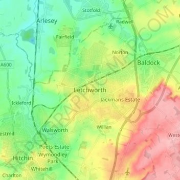
Nom : Carte topographique Letchworth, altitude, relief.
Altitude moyenne : 80 m
Altitude minimum : 33 m
Altitude maximum : 152 m

Cliquez sur la carte pour afficher l’altitude.
Nom : Carte topographique Letchworth, altitude, relief.
Altitude moyenne : 80 m
Altitude minimum : 33 m
Altitude maximum : 152 m
En tant que Partenaire Amazon, ce site perçoit une commission sur les achats éligibles sans surcoût pour vous.