
Carte topographique Děčín
Carte interactive
Cliquez sur la carte pour afficher l’altitude.
À propos de cette carte
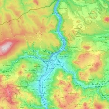
Nom : Carte topographique Děčín, altitude, relief.
Lieu : Děčín, okres Děčín, Ústecký kraj, Northwest, Czechia (50.70819 14.07778 50.86052 14.27165)
Altitude moyenne : 349 m
Altitude minimum : 119 m
Altitude maximum : 719 m
Děčín is located in northwestern Bohemia, at the confluence of the rivers Elbe and Ploučnice. The Elbe cut through the soft sandstone mountains of the region, and the city lies in the transition zone between Bohemian Switzerland and the Lusatian Mountains in the north and the Central Bohemian Uplands in the south. With the elevation of 135 metres (443 ft) in the river valley it is the lowest city in the country.