
Faire un don
Équipez-vous pour votre prochaine aventure :
En tant que Partenaire Amazon, ce site perçoit une commission sur les achats éligibles sans surcoût pour vous.
Carte topographique Stavelot
Cliquez sur la carte pour afficher l’altitude.
Faire un don
Équipez-vous pour votre prochaine aventure :
En tant que Partenaire Amazon, ce site perçoit une commission sur les achats éligibles sans surcoût pour vous.
Stavelot
Stavelot (Duits: Stablo, Waals: Ståvleu) is een stad aan de Amblève in de provincie Luik, arrondissement Verviers in België. De stad telt zo'n 7169 inwoners en ligt op een hoogte van 350m boven de zeespiegel.
Faire un don
Équipez-vous pour votre prochaine aventure :
En tant que Partenaire Amazon, ce site perçoit une commission sur les achats éligibles sans surcoût pour vous.
À propos de cette carte
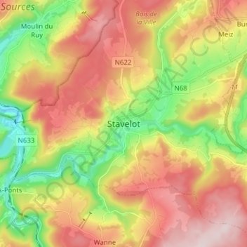
Nom : Carte topographique Stavelot, altitude, relief.
Lieu : Stavelot, Verviers, Luik, Wallonië, 4970, België (50.35424 5.89103 50.43424 5.97103)
Altitude moyenne : 401 m
Altitude minimum : 219 m
Altitude maximum : 585 m
Faire un don
Équipez-vous pour votre prochaine aventure :
En tant que Partenaire Amazon, ce site perçoit une commission sur les achats éligibles sans surcoût pour vous.
Autres cartes topographiques
Cliquez sur une carte pour visualiser sa topographie, son altitude et son relief.