
Faire un don
Équipez-vous pour votre prochaine aventure :
En tant que Partenaire Amazon, ce site perçoit une commission sur les achats éligibles sans surcoût pour vous.
Carte topographique Riverwest
Cliquez sur la carte pour afficher l’altitude.
Faire un don
Équipez-vous pour votre prochaine aventure :
En tant que Partenaire Amazon, ce site perçoit une commission sur les achats éligibles sans surcoût pour vous.
Riverwest
The Harambee community is just north of downtown Milwaukee and is bounded by Keefe Avenue to the north, Holton Street to the east, North Avenue to the south, and I-43 to the west. Harambee includes the highest residential elevation in the city, a tall ridge running along 1st Street. Between 1890 and 1910, well-to-do families built mansions on the North Side. Only a few are genuine mansions; the wealthiest Germans lived on the East and West Sides. Some are picturesque Queen Annes, with corner turrets and rambling floor plans. In 1984, the First Street corridor became an official historic district, listed on the National Register of Historic Places.
Faire un don
Équipez-vous pour votre prochaine aventure :
En tant que Partenaire Amazon, ce site perçoit une commission sur les achats éligibles sans surcoût pour vous.
À propos de cette carte
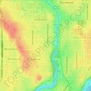
Nom : Carte topographique Riverwest, altitude, relief.
Lieu : Riverwest, Milwaukee, Wisconsin, 53201, United States (43.05577 -87.90538 43.08924 -87.89243)
Altitude moyenne : 206 m
Altitude minimum : 174 m
Altitude maximum : 227 m
Faire un don
Équipez-vous pour votre prochaine aventure :
En tant que Partenaire Amazon, ce site perçoit une commission sur les achats éligibles sans surcoût pour vous.