
Carte topographique Cannon Beach
Carte interactive
Cliquez sur la carte pour afficher l’altitude.
À propos de cette carte
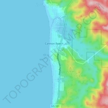
Nom : Carte topographique Cannon Beach, altitude, relief.
Lieu : Cannon Beach, Clatsop County, Oregon, United States (45.85893 -123.97004 45.91103 -123.94945)
Altitude moyenne : 42 m
Altitude minimum : -3 m
Altitude maximum : 250 m
Cannon Beach is recognized by the well-known landmark Haystack Rock, located southwest of downtown Cannon Beach. This sea stack has an elevation of 235 feet (72 m) and is often accessible at low tide, especially in the summertime. There is a small cave system that penetrates its igneous rock that can be seen from the coastline. The rock is also protected as part of Oregon Islands National Wildlife Refuge and events are not allowed within 100 feet (30 m) of either side of the rock. Near Haystack Rock are the Needles, two tall rocks rising straight out of the water.
Autres cartes topographiques
Cliquez sur une carte pour visualiser sa topographie, son altitude et son relief.
Astoria
United States > Oregon > Clatsop County
Astoria, Clatsop County, Oregon, 97103, United States
Altitude moyenne : 15 m
Seaside
United States > Oregon > Clatsop County
Seaside, Clatsop County, Oregon, United States
Altitude moyenne : 84 m
Flat Iron Mountain
United States > Oregon > Clatsop County
Flat Iron Mountain, Clatsop County, Oregon, United States
Altitude moyenne : 547 m
Westport
United States > Oregon > Clatsop County
Westport, Clatsop County, Oregon, United States
Altitude moyenne : 61 m
Svensen
United States > Oregon > Clatsop County
Svensen, Clatsop County, Oregon, United States
Altitude moyenne : 21 m
Knappa
United States > Oregon > Clatsop County
Knappa, Clatsop County, Oregon, United States
Altitude moyenne : 63 m
Astoria
United States > Oregon > Clatsop County > Astoria
Astoria, Clatsop County, Oregon, 97103, United States
Altitude moyenne : 17 m
Fishhawk Lake
United States > Oregon > Clatsop County
Fishhawk Lake, Clatsop County, Oregon, United States
Altitude moyenne : 257 m
Gearhart
United States > Oregon > Clatsop County
Gearhart, Clatsop County, Oregon, United States
Altitude moyenne : 17 m
Warrenton
United States > Oregon > Clatsop County
Warrenton, Clatsop County, Oregon, United States
Altitude moyenne : 4 m
Arch Cape
United States > Oregon > Clatsop County
Arch Cape, Clatsop County, Oregon, 97102, United States
Altitude moyenne : 73 m
Sunset Beach
United States > Oregon > Clatsop County
Sunset Beach, Clatsop County, Oregon, United States
Altitude moyenne : 11 m
Humbug Mountain
United States > Oregon > Clatsop County
Humbug Mountain, Clatsop County, Oregon, United States
Altitude moyenne : 463 m
Fort Stevens
United States > Oregon > Clatsop County > Hammond > Fort Stevens
Fort Stevens, Hammond, Clatsop County, Oregon, 97121, United States
Altitude moyenne : 3 m
Ecola State Park
United States > Oregon > Clatsop County > Seaside
Ecola State Park, Seaside, Clatsop County, Oregon, United States
Altitude moyenne : 64 m
Mishawaka
United States > Oregon > Clatsop County > Elderberry
Mishawaka, Elderberry, Clatsop County, Oregon, United States
Altitude moyenne : 204 m