
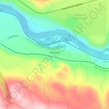
Carte topographique Walhachin
Carte interactive
Cliquez sur la carte pour afficher l’altitude.
À propos de cette carte
Nom : Carte topographique Walhachin, altitude, relief.
Altitude moyenne : 438 m
Altitude minimum : 315 m
Altitude maximum : 601 m
In December 1914, the westward advance of the CNoR rail head from Kamloops reached Walhachin. The track follows the valley floor at a much lower elevation than the hamlet proper.
Autres cartes topographiques
Cliquez sur une carte pour visualiser sa topographie, son altitude et son relief.
Barnes Lake
Canada > British Columbia > Thompson-Nicola Regional District > Area I (Blue Sky Country)
Barnes Lake, Area I (Blue Sky Country), Thompson-Nicola Regional District, British Columbia, Canada
Altitude moyenne : 752 m
Shaw Springs
Canada > British Columbia > Thompson-Nicola Regional District > Area I (Blue Sky Country)
Shaw Springs, Area I (Blue Sky Country), Thompson-Nicola Regional District, British Columbia, Canada
Altitude moyenne : 472 m
Spences Bridge
Canada > British Columbia > Thompson-Nicola Regional District > Area I (Blue Sky Country)
Spences Bridge, Area I (Blue Sky Country), Thompson-Nicola Regional District, British Columbia, V0K 2L0, Canada
Altitude moyenne : 495 m