
Carte topographique Grafton County
Carte interactive
Cliquez sur la carte pour afficher l’altitude.
À propos de cette carte
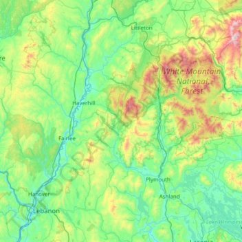
Nom : Carte topographique Grafton County, altitude, relief.
Lieu : Grafton County, New Hampshire, United States (43.52889 -72.33517 44.40621 -71.34686)
Altitude moyenne : 424 m
Altitude minimum : 94 m
Altitude maximum : 1’902 m
Autres cartes topographiques
Cliquez sur une carte pour visualiser sa topographie, son altitude et son relief.
Manchester
United States > New Hampshire > Hillsborough County
Manchester, Hillsborough County, New Hampshire, United States
Altitude moyenne : 96 m
Conway
United States > New Hampshire > Carroll County
Conway, Carroll County, New Hampshire, United States
Altitude moyenne : 256 m
Hampton Beach
United States > New Hampshire > Rockingham County > Hampton Beach
Hampton Beach, Hampton, Rockingham County, New Hampshire, 03842, United States
Altitude moyenne : 2 m
Seabrook Beach
United States > New Hampshire > Rockingham County > Seabrook
Seabrook Beach, Riverside, Seabrook, Rockingham County, New Hampshire, United States
Altitude moyenne : 1 m
Nashua
United States > New Hampshire > Hillsborough County
Nashua, Hillsborough County, New Hampshire, United States
Altitude moyenne : 62 m
North Conway
United States > New Hampshire > Carroll County > Conway
North Conway, Conway, Carroll County, New Hampshire, 03860, United States
Altitude moyenne : 173 m
Londonderry
United States > New Hampshire > Rockingham County
Londonderry, Rockingham County, New Hampshire, 03053, United States
Altitude moyenne : 91 m
Dover
United States > New Hampshire > Strafford County
Dover, Strafford County, New Hampshire, 03820, United States
Altitude moyenne : 31 m
Kidderville
United States > New Hampshire > Coos County > Colebrook
Kidderville, Colebrook, Coös County, New Hampshire, United States
Altitude moyenne : 472 m
Bedford
United States > New Hampshire > Hillsborough County
Bedford, Hillsborough County, New Hampshire, 03110, United States
Altitude moyenne : 97 m
Dixville
United States > New Hampshire > Coos County
Dixville, Coös County, New Hampshire, United States
Altitude moyenne : 635 m
East Alstead
United States > New Hampshire > Cheshire County > Alstead
East Alstead, Alstead, Cheshire County, New Hampshire, 03607, United States
Altitude moyenne : 418 m
Big Attitash Mountain
United States > New Hampshire > Carroll County > Bartlett
Big Attitash Mountain, Bartlett, Carroll County, New Hampshire, United States
Altitude moyenne : 711 m
West Peterborough
United States > New Hampshire > Hillsborough County > Peterborough
West Peterborough, Peterborough, Hillsborough County, New Hampshire, 03468, United States
Altitude moyenne : 299 m
Lyndeborough
United States > New Hampshire > Hillsborough County
Lyndeborough, Hillsborough County, New Hampshire, 03082, United States
Altitude moyenne : 245 m
East Merrimack
United States > New Hampshire > Hillsborough County > Merrimack
East Merrimack, Merrimack, Hillsborough County, New Hampshire, 03054, United States
Altitude moyenne : 55 m
Pinardville
United States > New Hampshire > Hillsborough County > Goffstown
Pinardville, Goffstown, Hillsborough County, New Hampshire, 03102, United States
Altitude moyenne : 86 m
Grasmere
United States > New Hampshire > Hillsborough County > Goffstown
Grasmere, Goffstown, Hillsborough County, New Hampshire, 03045, United States
Altitude moyenne : 115 m
Reeds Ferry
United States > New Hampshire > Hillsborough County > Merrimack
Reeds Ferry, Merrimack, Hillsborough County, New Hampshire, 03054, United States
Altitude moyenne : 58 m
Mount Washington
United States > New Hampshire > Coos County
Mount Washington, Coös County, New Hampshire, United States
Altitude moyenne : 1’568 m
Bond Hill
United States > New Hampshire > Rockingham County > Derry
Bond Hill, Derry, Rockingham County, New Hampshire, 03841, United States
Altitude moyenne : 79 m
East Hebron
United States > New Hampshire > Grafton County > Hebron
East Hebron, Hebron, Grafton County, New Hampshire, 03241, United States
Altitude moyenne : 268 m
Montcalm
United States > New Hampshire > Grafton County
Montcalm, Grafton County, New Hampshire, 03748, United States
Altitude moyenne : 436 m
Ashland
United States > New Hampshire > Grafton County
Ashland, Grafton County, New Hampshire, 03217, United States
Altitude moyenne : 231 m
Easton
United States > New Hampshire > Grafton County
Easton, Grafton County, New Hampshire, United States
Altitude moyenne : 586 m
Lyme Center
United States > New Hampshire > Grafton County > Lyme
Lyme Center, Lyme, Grafton County, New Hampshire, 03769, United States
Altitude moyenne : 336 m
Pike
United States > New Hampshire > Grafton County > Haverhill
Pike, Haverhill, Grafton County, New Hampshire, 03765, United States
Altitude moyenne : 287 m
Stinson Lake
United States > New Hampshire > Grafton County > Rumney > Stinson Lake
Stinson Lake, Rumney, Grafton County, New Hampshire, United States
Altitude moyenne : 460 m
West Lebanon
United States > New Hampshire > Grafton County > Lebanon
West Lebanon, Lebanon, Grafton County, New Hampshire, 03784, United States
Altitude moyenne : 165 m
Benton
United States > New Hampshire > Grafton County
Benton, Grafton County, New Hampshire, United States
Altitude moyenne : 558 m
Bridgewater
United States > New Hampshire > Grafton County
Bridgewater, Grafton County, New Hampshire, United States
Altitude moyenne : 302 m
Holderness
United States > New Hampshire > Grafton County
Holderness, Grafton County, New Hampshire, 03245, United States
Altitude moyenne : 252 m
Monroe
United States > New Hampshire > Grafton County
Monroe, Grafton County, New Hampshire, 03771, United States
Altitude moyenne : 320 m
North Woodstock
United States > New Hampshire > Grafton County > Woodstock
North Woodstock, Woodstock, Grafton County, New Hampshire, 03262, United States
Altitude moyenne : 306 m
Woodsville
United States > New Hampshire > Grafton County > Haverhill
Woodsville, Haverhill, Grafton County, New Hampshire, 05081, United States
Altitude moyenne : 195 m
Enfield Center
United States > New Hampshire > Grafton County > Enfield
Enfield Center, Enfield, Grafton County, New Hampshire, 03749, United States
Altitude moyenne : 357 m
Glencliff
United States > New Hampshire > Grafton County > Warren
Glencliff, Warren, Grafton County, New Hampshire, 03238, United States
Altitude moyenne : 410 m
Rochester
United States > New Hampshire > Strafford County
Rochester, Strafford County, New Hampshire, United States
Altitude moyenne : 90 m
Bradford
United States > New Hampshire > Merrimack County
Bradford, Merrimack County, New Hampshire, United States
Altitude moyenne : 316 m
Eidelweiss Beach
United States > New Hampshire > Carroll County > Madison
Eidelweiss Beach, Madison, Carroll County, New Hampshire, United States
Altitude moyenne : 236 m
Webster
United States > New Hampshire > Merrimack County
Webster, Merrimack County, New Hampshire, United States
Altitude moyenne : 166 m
South Alexandria
United States > New Hampshire > Merrimack County > Hill
South Alexandria, Hill, Merrimack County, New Hampshire, United States
Altitude moyenne : 261 m
Jewell Hill
United States > New Hampshire > Grafton County > Groton
Jewell Hill, Groton, Grafton County, New Hampshire, United States
Altitude moyenne : 466 m
Jewell Hill
United States > New Hampshire > Rockingham County > Stratham
Jewell Hill, Stratham, Rockingham County, New Hampshire, 03885, United States
Altitude moyenne : 36 m
Exeter
United States > New Hampshire > Rockingham County
Exeter, Rockingham County, New Hampshire, United States
Altitude moyenne : 24 m
Northumberland
United States > New Hampshire > Coos County
Northumberland, Coös County, New Hampshire, United States
Altitude moyenne : 383 m
Auburn
United States > New Hampshire > Rockingham County
Auburn, Rockingham County, New Hampshire, 03032, United States
Altitude moyenne : 107 m
Boutin Corner
United States > New Hampshire > Grafton County > Benton
Boutin Corner, Benton, Grafton County, New Hampshire, United States
Altitude moyenne : 446 m
East Wakefield
United States > New Hampshire > Carroll County > Wakefield
East Wakefield, Wakefield, Carroll County, New Hampshire, 03830, United States
Altitude moyenne : 206 m
Stark
United States > New Hampshire > Coos County
Stark, Coös County, New Hampshire, United States
Altitude moyenne : 526 m