
Carte topographique Manchester
Carte interactive
Cliquez sur la carte pour afficher l’altitude.
À propos de cette carte
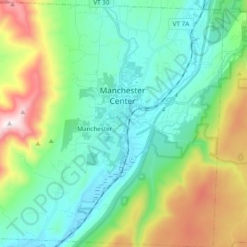
Nom : Carte topographique Manchester, altitude, relief.
Lieu : Manchester, Bennington County, Vermont, United States (43.11664 -73.13504 43.21472 -73.00170)
Altitude moyenne : 453 m
Altitude minimum : 189 m
Altitude maximum : 1’163 m
Manchester is located in north-central Bennington County, lying between the Green Mountains to the east and the Taconic Range to the west. Equinox Mountain, the highest summit in the Taconics, with an elevation of 3,850 feet (1,170 m), is in the western part of the town. Manchester is drained by the Batten Kill, Lye Brook, Munson Brook, Bromley Brook, and Bourn Brook. The Lye Brook Falls Hiking Trail which leads to one of the highest waterfalls in Vermont is a popular local attraction.
Autres cartes topographiques
Cliquez sur une carte pour visualiser sa topographie, son altitude et son relief.
Searsburg
United States > Vermont > Bennington County
Searsburg, Bennington County, Vermont, United States
Altitude moyenne : 675 m
North Bennington
United States > Vermont > Bennington County > Bennington
North Bennington, Bennington, Bennington County, Vermont, 05257, United States
Altitude moyenne : 196 m
Bennington
United States > Vermont > Bennington County
Bennington, Bennington County, Vermont, United States
Altitude moyenne : 352 m
Pownal
United States > Vermont > Bennington County
Pownal, Bennington County, Vermont, United States
Altitude moyenne : 369 m
Readsboro Falls
United States > Vermont > Bennington County > Readsboro
Readsboro Falls, Readsboro, Bennington County, Vermont, 05350, United States
Altitude moyenne : 637 m
Landgrove
United States > Vermont > Bennington County
Landgrove, Bennington County, Vermont, United States
Altitude moyenne : 479 m
Woodford
United States > Vermont > Bennington County > Woodford
Woodford, Bennington County, Vermont, 05201, United States
Altitude moyenne : 670 m
Sandgate
United States > Vermont > Bennington County
Sandgate, Bennington County, Vermont, United States
Altitude moyenne : 480 m
Rupert
United States > Vermont > Bennington County
Rupert, Bennington County, Vermont, United States
Altitude moyenne : 360 m
Shaftsbury
United States > Vermont > Bennington County
Shaftsbury, Bennington County, Vermont, 05262, United States
Altitude moyenne : 395 m
Stamford
United States > Vermont > Bennington County
Stamford, Bennington County, Vermont, 05352, United States
Altitude moyenne : 646 m