
Faire un don
Équipez-vous pour votre prochaine aventure :
En tant que Partenaire Amazon, ce site perçoit une commission sur les achats éligibles sans surcoût pour vous.
Carte topographique Connersville
Cliquez sur la carte pour afficher l’altitude.
Faire un don
Équipez-vous pour votre prochaine aventure :
En tant que Partenaire Amazon, ce site perçoit une commission sur les achats éligibles sans surcoût pour vous.
Connersville
Most of the town is located on the north bank of the west fork of the Whitewater River. The town is at modest elevation, a little over 800 feet (240 m) above sea level. The local area has nearly flat to gently rolling topography. The local region (and all of Fayette County and the state of Indiana) are part of the Eastern (U.S.) Broadleaf Forest Environment biome. Much of the surrounding Whitewater Valley vegetation would be classified as riparian woodland or gallery forest. There are 124 native tree species, including 17 varieties of oak, as well as black walnut, sycamore, and tulip tree (yellow poplar), the state tree. Fruit trees—apple, cherry, peach, and pear—are common. Common native mammals are the red fox, common cottontail, muskrat, raccoon, opossum, and several types of squirrel.
Faire un don
Équipez-vous pour votre prochaine aventure :
En tant que Partenaire Amazon, ce site perçoit une commission sur les achats éligibles sans surcoût pour vous.
À propos de cette carte
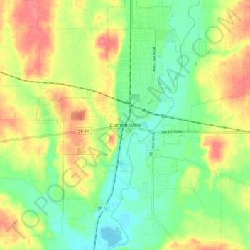
Nom : Carte topographique Connersville, altitude, relief.
Lieu : Connersville, Fayette County, Indiana, 47331, United States (39.60116 -85.18107 39.68116 -85.10107)
Altitude moyenne : 269 m
Altitude minimum : 236 m
Altitude maximum : 313 m
Faire un don
Équipez-vous pour votre prochaine aventure :
En tant que Partenaire Amazon, ce site perçoit une commission sur les achats éligibles sans surcoût pour vous.