
Carte topographique Telluride
Carte interactive
Cliquez sur la carte pour afficher l’altitude.
À propos de cette carte
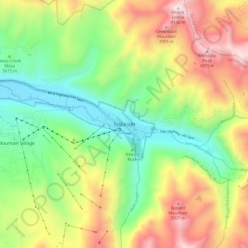
Nom : Carte topographique Telluride, altitude, relief.
Altitude moyenne : 3’246 m
Altitude minimum : 2’638 m
Altitude maximum : 4’135 m
Telluride has an elevation of 8,750 feet (2,670 m) in an isolated spot in Southwest Colorado. From the west, Colorado Route 145 is the most common way into Telluride; two other passes enter the town, Imogene Pass and Black Bear Pass.