
Carte topographique Kingston St. Mary
Carte interactive
Cliquez sur la carte pour afficher l’altitude.
À propos de cette carte
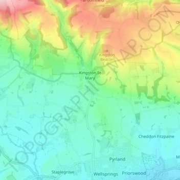
Nom : Carte topographique Kingston St. Mary, altitude, relief.
Altitude moyenne : 92 m
Altitude minimum : 13 m
Altitude maximum : 280 m
Autres cartes topographiques
Cliquez sur une carte pour visualiser sa topographie, son altitude et son relief.
Nailsbourne
United Kingdom > England > Somerset > Somerset West and Taunton > Kingston St. Mary > Nailsbourne
Nailsbourne, Kingston St. Mary, Somerset West and Taunton, Somerset, South West England, England, TA2 8AG, United Kingdom
Altitude moyenne : 66 m