
Carte topographique Great Falls
Carte interactive
Cliquez sur la carte pour afficher l’altitude.
À propos de cette carte
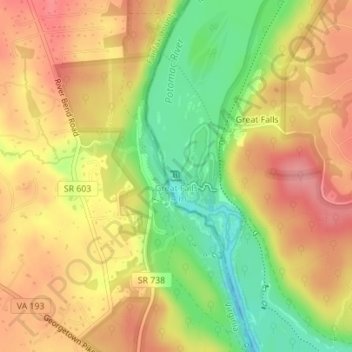
Nom : Carte topographique Great Falls, altitude, relief.
Altitude moyenne : 73 m
Altitude minimum : 17 m
Altitude maximum : 115 m
The rocks of the falls date to the late Precambrian and are about 750 million years old. The rocks are a resistant metamorphized schist, gneisses, metagraywackes, and metaconglomerates. The Falls formed the last time sea level dropped, during the Last Glacial Period about 35,000 years ago, causing the Potomac to downcut its valley. The river cascades over a series of 20-foot (6.1 m) falls, dropping a total of 76 feet (23 m) in elevation over a distance of less than 1 mile (1.6 km). As sea level rises again, the power of the falls will be reduced due to a shorter vertical drop and likewise downcutting will slow down. Should the ocean level ever exceed the height of the falls again, downcutting would reverse entirely with silt filling in the now-underwater falls.
Autres cartes topographiques
Cliquez sur une carte pour visualiser sa topographie, son altitude et son relief.
Deerfield
United States > Maryland > Montgomery County > Potomac
Deerfield, Potomac, Montgomery County, Maryland, 20817, United States
Altitude moyenne : 84 m
Campbell Corner
United States > Maryland > Montgomery County > Potomac
Campbell Corner, Potomac, Montgomery County, Maryland, 20818, United States
Altitude moyenne : 82 m