
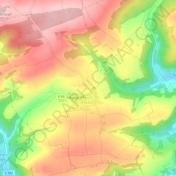
Carte topographique Desloch
Carte interactive
Cliquez sur la carte pour afficher l’altitude.
À propos de cette carte
Nom : Carte topographique Desloch, altitude, relief.
Altitude moyenne : 300 m
Altitude minimum : 177 m
Altitude maximum : 388 m
Autres cartes topographiques
Cliquez sur une carte pour visualiser sa topographie, son altitude et son relief.
Stromberg
Deutschland > Rheinland-Pfalz > Landkreis Bad Kreuznach
Stromberg, Langenlonsheim-Stromberg, Landkreis Bad Kreuznach, Rheinland-Pfalz, 55442, Deutschland
Altitude moyenne : 325 m
Langenthal
Deutschland > Rheinland-Pfalz > Landkreis Bad Kreuznach
Langenthal, Nahe-Glan, Landkreis Bad Kreuznach, Rheinland-Pfalz, Deutschland
Altitude moyenne : 319 m
Rüdesheim
Deutschland > Rheinland-Pfalz > Landkreis Bad Kreuznach
Rüdesheim, Landkreis Bad Kreuznach, Rheinland-Pfalz, 55593, Deutschland
Altitude moyenne : 165 m