Géolocaliser

Carte topographique Murrayfield

Cliquez sur la carte pour afficher l’altitude.

À propos de cette carte

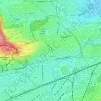
Nom : Carte topographique Murrayfield, altitude, relief.

Lieu : Murrayfield, City of Edinburgh, Scotland, United Kingdom (55.93813 -3.26950 55.95689 -3.22397)

Altitude moyenne : 59 m

Altitude minimum : 22 m

Altitude maximum : 164 m

Autres cartes topographiques

Cliquez sur une carte pour visualiser sa topographie, son altitude et son relief.

Crow Hill

United Kingdom > Scotland > City of Edinburgh

Altitude moyenne : 68 m

Hillend

United Kingdom > Scotland > City of Edinburgh > Ratho

Altitude moyenne : 67 m

Newbridge

United Kingdom > Scotland > City of Edinburgh

Altitude moyenne : 54 m

Gogarbank

United Kingdom > Scotland > City of Edinburgh

Altitude moyenne : 69 m

Hillend

United Kingdom > Scotland > City of Edinburgh > Ratho

Altitude moyenne : 67 m

Ratho

United Kingdom > Scotland > City of Edinburgh

Altitude moyenne : 80 m

Gogar

United Kingdom > Scotland > City of Edinburgh

Altitude moyenne : 51 m

Équipez-vous pour votre prochaine aventure :

🧺Couverture de survie - Équipement de sécurité vital pour prévenir l'hypothermie
📷Appareils photo outdoor - Capture en conditions difficiles
🧳Sacs de transport outdoor - Organisation du matériel
🔭Jumelles de randonnée - Compactes et légères pour observer le relief et la faune des Alpes
🚴Sacs d’hydratation - Hydratation en mouvement

En tant que Partenaire Amazon, ce site perçoit une commission sur les achats éligibles sans surcoût pour vous.