
Carte topographique Trysull
Cliquez sur la carte pour afficher l’altitude.
À propos de cette carte
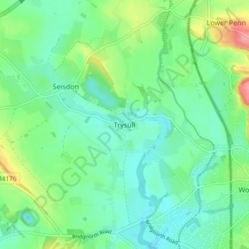
Nom : Carte topographique Trysull, altitude, relief.
Altitude moyenne : 94 m
Altitude minimum : 68 m
Altitude maximum : 160 m
Autres cartes topographiques
Cliquez sur une carte pour visualiser sa topographie, son altitude et son relief.
Weston Park
United Kingdom > England > Staffordshire > South Staffordshire > Weston under Lizard
Altitude moyenne : 113 m
Himley
United Kingdom > England > Staffordshire > South Staffordshire > Himley
Altitude moyenne : 118 m
Highgate Common
United Kingdom > England > Staffordshire > South Staffordshire > Enville
Altitude moyenne : 92 m
Mottey Meadows NNR
United Kingdom > England > Staffordshire > South Staffordshire > Wheaton Aston
Altitude moyenne : 110 m
Shareshill
United Kingdom > England > Staffordshire > South Staffordshire > Shareshill
Altitude moyenne : 123 m
Baggeridge Country Park
United Kingdom > England > Staffordshire > South Staffordshire
Altitude moyenne : 146 m
Wombourne
United Kingdom > England > Staffordshire > South Staffordshire > Wombourne
Altitude moyenne : 112 m
Cannock Lake
United Kingdom > England > Staffordshire > South Staffordshire > Huntington
Altitude moyenne : 149 m