
Carte topographique Clearfield
Carte interactive
Cliquez sur la carte pour afficher l’altitude.
À propos de cette carte
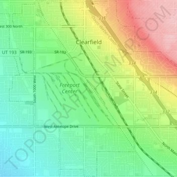
Nom : Carte topographique Clearfield, altitude, relief.
Lieu : Clearfield, Davis County, Utah, 84015, United States (41.07467 -112.05495 41.12536 -111.98717)
Altitude moyenne : 1’358 m
Altitude minimum : 1’300 m
Altitude maximum : 1’460 m
Clearfield City has a total land area of 7.8 square miles (20 km2), and a population of 31,909 as of the 2020 Census, making it the fifth largest city in Davis County, behind Layton, Bountiful, Kaysville, and Syracuse. This creates a population density of 1498.1 people per square kilometer or 3860.5 people per square mile. Clearfield City has an average elevation of 4,327 feet (1,319 m) above sea level. The lowest point within the boundaries of the city is 4,314 feet (1,315 m) at the intersection of 1000 West and Antelope Drive on the city's western edge, and the highest is 4,711 feet (1,436 m) at a point that is within the city's northeast corner but physically located on Hill Air Force Base property along Constitution Way in their housing area. (AGRC)
Autres cartes topographiques
Cliquez sur une carte pour visualiser sa topographie, son altitude et son relief.
Bountiful
United States > Utah > Davis County
Bountiful, Davis County, Utah, 84010, United States
Altitude moyenne : 1’477 m
Layton
United States > Utah > Davis County
Layton, Davis County, Utah, United States
Altitude moyenne : 1’373 m
Campbell
United States > Utah > Davis County > Bountiful
Campbell, Bountiful, Davis County, Utah, 84014, United States
Altitude moyenne : 1’347 m
White
United States > Utah > Davis County > Sunset
White, Sunset, Davis County, Utah, 84015, United States
Altitude moyenne : 1’382 m
West Point
United States > Utah > Davis County
West Point, Davis County, Utah, United States
Altitude moyenne : 1’309 m
Mountains Meadows
United States > Utah > Davis County > North Salt Lake
Mountains Meadows, North Salt Lake, Davis County, Utah, 84054, United States
Altitude moyenne : 1’411 m
Newmann
United States > Utah > Davis County > Farmington
Newmann, Farmington, Davis County, Utah, 84025, United States
Altitude moyenne : 1’507 m
Clinton
United States > Utah > Davis County
Clinton, Davis County, Utah, United States
Altitude moyenne : 1’341 m
Woods Cross
United States > Utah > Davis County
Woods Cross, Davis County, Utah, 84087, United States
Altitude moyenne : 1’351 m
The Great Salt Lake Shorelands Preserve
United States > Utah > Davis County
The Great Salt Lake Shorelands Preserve, Davis County, Utah, United States
Altitude moyenne : 1’292 m
North Salt Lake
United States > Utah > Davis County
North Salt Lake, Davis County, Utah, 84054, United States
Altitude moyenne : 1’429 m
Syracuse
United States > Utah > Davis County
Syracuse, Davis County, Utah, 84075, United States
Altitude moyenne : 1’305 m
West Bountiful
United States > Utah > Davis County
West Bountiful, Davis County, Utah, United States
Altitude moyenne : 1’300 m
North Salt Lake
United States > Utah > Davis County > North Salt Lake > North Salt Lake
North Salt Lake, Davis County, Utah, 84054, United States
Altitude moyenne : 1’422 m
Farmington
United States > Utah > Davis County > Farmington > Farmington
Farmington, Davis County, Utah, 84025, United States
Altitude moyenne : 1’595 m
Kaysville
United States > Utah > Davis County
Kaysville, Davis County, Utah, 84037, United States
Altitude moyenne : 1’353 m
Centerville
United States > Utah > Davis County
Centerville, Davis County, Utah, 84014, United States
Altitude moyenne : 1’521 m
Farmington
United States > Utah > Davis County
Farmington, Davis County, Utah, 84025, United States
Altitude moyenne : 1’553 m