
Carte topographique Albany
Carte interactive
Cliquez sur la carte pour afficher l’altitude.
À propos de cette carte
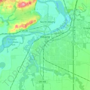
Nom : Carte topographique Albany, altitude, relief.
Lieu : Albany, Linn County, Oregon, United States (44.57758 -123.14740 44.67675 -123.03266)
Altitude moyenne : 71 m
Altitude minimum : 48 m
Altitude maximum : 158 m
According to the United States Census Bureau, the city has a total area of 17.75 square miles (45.97 km2), of which 17.54 square miles (45.43 km2) is land and 0.21 square miles (0.54 km2) is water. Albany has 21.7 square miles (56 km2) within its urban growth boundary. Throughout the city limits and urban growth area, there are limited hills; the city is one of the lowest points along the Willamette Valley, with elevations ranging 180 to 430 feet (55 to 131 m) above sea level. The North Albany District has the most variable elevation, while the downtown and southern end of town have little elevation change throughout.
Autres cartes topographiques
Cliquez sur une carte pour visualiser sa topographie, son altitude et son relief.
Tangent
United States > Oregon > Linn County
Tangent, Linn County, Oregon, United States
Altitude moyenne : 75 m
Millersburg
United States > Oregon > Linn County
Millersburg, Linn County, Oregon, United States
Altitude moyenne : 73 m
Lebanon
United States > Oregon > Linn County
Lebanon, Linn County, Oregon, 97355, United States
Altitude moyenne : 117 m
Menagerie Wilderness
United States > Oregon > Linn County
Menagerie Wilderness, Forest Road 306, Linn County, Oregon, United States
Altitude moyenne : 819 m
Cascadia
United States > Oregon > Linn County
Cascadia, Linn County, Oregon, 97329, United States
Altitude moyenne : 415 m
Scio
United States > Oregon > Linn County
Scio, Linn County, Oregon, 97374, United States
Altitude moyenne : 106 m
Mill City
United States > Oregon > Linn County
Mill City, Linn County, Oregon, 97360, United States
Altitude moyenne : 292 m
Halsey
United States > Oregon > Linn County
Halsey, Linn County, Oregon, United States
Altitude moyenne : 86 m
Lyons
United States > Oregon > Linn County
Lyons, Linn County, Oregon, United States
Altitude moyenne : 223 m
Ward Butte
United States > Oregon > Linn County
Ward Butte, Linn County, Oregon, United States
Altitude moyenne : 89 m
Brownsville
United States > Oregon > Linn County
Brownsville, Linn County, Oregon, 97327, United States
Altitude moyenne : 116 m
Ed Rogers Wayside
United States > Oregon > Linn County
Ed Rogers Wayside, Linn County, Oregon, United States
Altitude moyenne : 492 m
Sodaville
United States > Oregon > Linn County > Sodaville
Sodaville, Linn County, Oregon, United States
Altitude moyenne : 168 m
Sweet Home
United States > Oregon > Linn County
Sweet Home, Linn County, Oregon, 97386, United States
Altitude moyenne : 230 m
Jordan
United States > Oregon > Linn County > Jordan
Jordan, Linn County, Oregon, United States
Altitude moyenne : 200 m
Lacomb
United States > Oregon > Linn County
Lacomb, Linn County, Oregon, United States
Altitude moyenne : 189 m
Middle Santiam Wilderness
United States > Oregon > Linn County
Middle Santiam Wilderness, Linn County, Oregon, United States
Altitude moyenne : 953 m
Mount Washington Wilderness
United States > Oregon > Linn County
Mount Washington Wilderness, Linn County, Oregon, United States
Altitude moyenne : 1’500 m