

Faire un don
Équipez-vous pour votre prochaine aventure :
En tant que Partenaire Amazon, ce site perçoit une commission sur les achats éligibles sans surcoût pour vous.
Carte topographique Alma
Cliquez sur la carte pour afficher l’altitude.
Faire un don
Équipez-vous pour votre prochaine aventure :
En tant que Partenaire Amazon, ce site perçoit une commission sur les achats éligibles sans surcoût pour vous.
Alma
At an elevation of approximately 10,578 feet (3,224 m), Alma is the highest incorporated municipality in the United States when considering only areas with permanent residents. Its post office is located at the highest elevation of any in the country. Alma, which is considered a town and not a city, does not take the title of "highest incorporated city" from Leadville, Colorado. Using administrative boundaries as a measure, not settled areas, in 2006 Winter Park, Colorado became the highest incorporated town due to its annexation of a ski area. Beyond the official limits of Alma is a residential area which extends to 11,680 feet (3,560 m) above sea level on Mountain View Drive; this area uses Fairplay, Colorado addresses, despite being slightly closer to Alma.
Faire un don
Équipez-vous pour votre prochaine aventure :
En tant que Partenaire Amazon, ce site perçoit une commission sur les achats éligibles sans surcoût pour vous.
À propos de cette carte
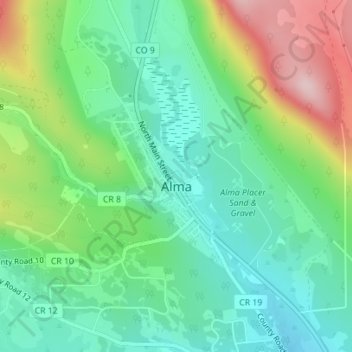
Nom : Carte topographique Alma, altitude, relief.
Lieu : Alma, Park County, Colorado, United States (39.27882 -106.07355 39.29062 -106.05817)
Altitude moyenne : 3’212 m
Altitude minimum : 3’124 m
Altitude maximum : 3’392 m
Faire un don
Équipez-vous pour votre prochaine aventure :
En tant que Partenaire Amazon, ce site perçoit une commission sur les achats éligibles sans surcoût pour vous.