
Carte topographique Travemünde
Carte interactive
Cliquez sur la carte pour afficher l’altitude.
À propos de cette carte
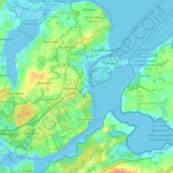
Nom : Carte topographique Travemünde, altitude, relief.
Lieu : Travemünde, Lübeck, Schleswig-Holstein, 23570, Germany (53.88567 10.80089 53.99389 10.96863)
Altitude moyenne : 10 m
Altitude minimum : -4 m
Altitude maximum : 48 m
Autres cartes topographiques
Cliquez sur une carte pour visualiser sa topographie, son altitude et son relief.
Lübeck
Germany > Schleswig-Holstein > Lübeck
Lübeck, Schleswig-Holstein, 23552, Germany
Altitude moyenne : 29 m
Sankt Gertrud
Germany > Schleswig-Holstein > Lübeck > Marli
Sankt Gertrud, Marli, Lübeck, Schleswig-Holstein, 23566, Germany
Altitude moyenne : 11 m