
Carte topographique Tegucigalpa
Carte interactive
Cliquez sur la carte pour afficher l’altitude.
À propos de cette carte
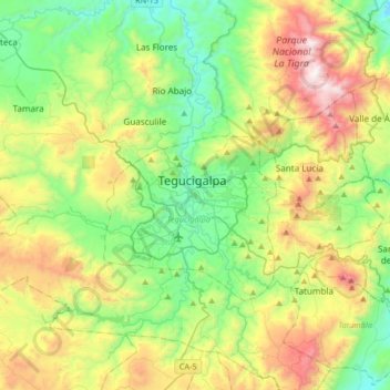
Nom : Carte topographique Tegucigalpa, altitude, relief.
Lieu : Tegucigalpa, Francisco Morazán, 12101, Honduras (13.94574 -87.36401 14.26574 -87.04401)
Altitude moyenne : 1’280 m
Altitude minimum : 787 m
Altitude maximum : 2’304 m
Tegucigalpa is located on a chain of mountains with elevations of 975 metres (3,199 ft) at its lowest points and 1,463 metres (4,800 ft) at its highest suburban areas. Like most of the interior highlands of Honduras, the majority of Tegucigalpa's current area was occupied by open woodland. The area surrounding the city continues to be open woodland supporting pine forest interspersed with some oak, scrub, and grassy clearings as well as needle leaf evergreen and broadleaf deciduous forest.