
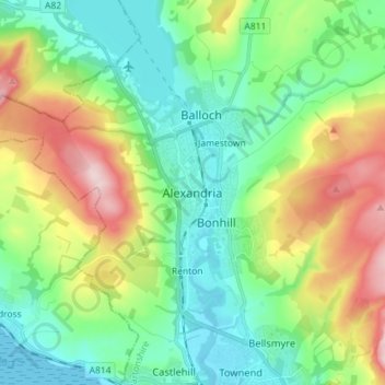
Carte topographique Alexandria
Carte interactive
Cliquez sur la carte pour afficher l’altitude.
À propos de cette carte
Nom : Carte topographique Alexandria, altitude, relief.
Altitude moyenne : 95 m
Altitude minimum : -3 m
Altitude maximum : 303 m
Autres cartes topographiques
Cliquez sur une carte pour visualiser sa topographie, son altitude et son relief.
Faifley
United Kingdom > Scotland > West Dunbartonshire
Faifley, West Dunbartonshire, Scotland, G81 5EB, United Kingdom
Altitude moyenne : 112 m
Clydebank
United Kingdom > Scotland > West Dunbartonshire
Clydebank, West Dunbartonshire, Scotland, G81 2UA, United Kingdom
Altitude moyenne : 44 m
Dumbarton
United Kingdom > Scotland > West Dunbartonshire
Dumbarton, West Dunbartonshire, Scotland, G82 1LG, United Kingdom
Altitude moyenne : 75 m
Cochno Hill
United Kingdom > Scotland > West Dunbartonshire
Cochno Hill, West Dunbartonshire, Scotland, G81 6RW, United Kingdom
Altitude moyenne : 269 m
Bonhill
United Kingdom > Scotland > West Dunbartonshire
Bonhill, West Dunbartonshire, Scotland, G83 9HS, United Kingdom
Altitude moyenne : 101 m
Cochno
United Kingdom > Scotland > West Dunbartonshire > Faifley > Cochno
Cochno, Faifley, West Dunbartonshire, Scotland, G81 5QJ, United Kingdom
Altitude moyenne : 178 m
Gartocharn
United Kingdom > Scotland > West Dunbartonshire
Gartocharn, West Dunbartonshire, Scotland, G83 8RX, United Kingdom
Altitude moyenne : 54 m
Bowling
United Kingdom > Scotland > West Dunbartonshire
Bowling, West Dunbartonshire, Scotland, G60 5AH, United Kingdom
Altitude moyenne : 105 m
Tullichewan Muir
United Kingdom > Scotland > West Dunbartonshire > Alexandria > Upper Stoneymollan
Tullichewan Muir, Upper Stoneymollan, Alexandria, West Dunbartonshire, Scotland, G83 8QU, United Kingdom
Altitude moyenne : 169 m