Géolocaliser

Carte topographique Lappach

Carte interactive

Cliquez sur la carte pour afficher l’altitude.

À propos de cette carte

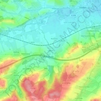
Nom : Carte topographique Lappach, altitude, relief.

Lieu : Lappach, Dorfen, Landkreis Erding, Bayern, 84405, Deutschland (48.23759 12.11381 48.27759 12.15381)

Altitude moyenne : 478 m

Altitude minimum : 436 m

Altitude maximum : 551 m

Autres cartes topographiques

Cliquez sur une carte pour visualiser sa topographie, son altitude et son relief.

Wolfeck

Deutschland > Bayern > Landkreis Erding > Dorfen

Wolfeck, Dorfen, Landkreis Erding, Bayern, 84419, Deutschland

Altitude moyenne : 457 m

Eibach

Deutschland > Bayern > Landkreis Erding > Dorfen

Eibach, Dorfen, Landkreis Erding, Bayern, 84405, Deutschland

Altitude moyenne : 481 m

Schwindkirchen

Deutschland > Bayern > Landkreis Erding > Dorfen

Schwindkirchen, Dorfen, Landkreis Erding, Bayern, 84419, Deutschland

Altitude moyenne : 468 m