
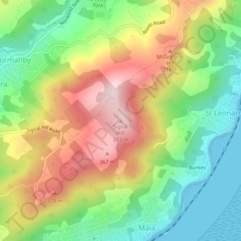
Carte topographique Signal Hill
Carte interactive
Cliquez sur la carte pour afficher l’altitude.
À propos de cette carte
Nom : Carte topographique Signal Hill, altitude, relief.
Altitude moyenne : 174 m
Altitude minimum : 0 m
Altitude maximum : 398 m
Signal Hill (Maori: Te Pahuri o te Rangipohika) is a prominent landform in the city of Dunedin, New Zealand. It is located close to, and due north of, the head of the Otago Harbour and reaches an elevation of 393 m (1289 ft). The suburbs Ravensbourne, St. Leonards, and Opoho lie on its southern, eastern, and northwestern flanks, respectively. To the northwest is North East Valley, the thalweg of Lindsay Creek, a tributary of the Water of Leith. The southernmost spur of Signal Hill, Logan Point, has been extensively quarried for road gravel. State Highway 88 skirts the foot of the hill close to the edge of the Otago Harbour.
Autres cartes topographiques
Cliquez sur une carte pour visualiser sa topographie, son altitude et son relief.
The Cove
New Zealand > Otago > Dunedin City > Dunedin > The Cove
The Cove, Dunedin, Dunedin City, Otago, 9013, New Zealand
Altitude moyenne : 59 m