
Carte topographique Lavaca
Carte interactive
Cliquez sur la carte pour afficher l’altitude.
À propos de cette carte
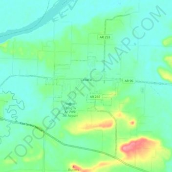
Nom : Carte topographique Lavaca, altitude, relief.
Lieu : Lavaca, Sebastian County, Arkansas, 72941, United States (35.30176 -94.22696 35.36495 -94.13476)
Altitude moyenne : 134 m
Altitude minimum : 112 m
Altitude maximum : 201 m
Autres cartes topographiques
Cliquez sur une carte pour visualiser sa topographie, son altitude et son relief.
Hackett
United States > Arkansas > Sebastian County
Hackett, Sebastian County, Arkansas, United States
Altitude moyenne : 167 m
Barling
United States > Arkansas > Sebastian County
Barling, Sebastian County, Arkansas, 72923, United States
Altitude moyenne : 136 m
Fort Smith
United States > Arkansas > Sebastian County
Fort Smith, Sebastian County, Arkansas, United States
Altitude moyenne : 140 m
Fort Smith
United States > Arkansas > Sebastian County > Fort Smith
Fort Smith, Sebastian County, Arkansas, 72901, United States
Altitude moyenne : 163 m
Greenwood
United States > Arkansas > Sebastian County
Greenwood, Sebastian County, Arkansas, 72936, United States
Altitude moyenne : 179 m