Géolocaliser

Carte topographique Unteriberg

Carte interactive

Cliquez sur la carte pour afficher l’altitude.

À propos de cette carte

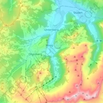
Nom : Carte topographique Unteriberg, altitude, relief.

Lieu : Unteriberg, Schwyz, Schweiz (47.00242 8.76144 47.07999 8.88890)

Altitude moyenne : 1’346 m

Altitude minimum : 885 m

Altitude maximum : 2’269 m

Die Gemeinde Unteriberg liegt auf rund 900 m Höhe und erstreckt sich im Höch-Hund bis auf 2215 m über Meer. Der Waldanteil beträgt 35 %, der Landwirtschaft dienen 45 % der Gemeindefläche und 18 % ist unproduktiv.

Wikipedia (CC-BY-SA 3.0)

Autres cartes topographiques

Cliquez sur une carte pour visualiser sa topographie, son altitude et son relief.

Ingenbohl

Schweiz > Schwyz > Schwyz

Ingenbohl, Schwyz, 6440, Schweiz

Altitude moyenne : 674 m

Illgau

Schweiz > Schwyz > Schwyz

Illgau, Schwyz, 6434, Schweiz

Altitude moyenne : 1’108 m

Stalden

Schweiz > Schwyz > Schwyz

Stalden, Muotathal, Schwyz, 6436, Schweiz

Altitude moyenne : 1’067 m

Schulhaus

Schweiz > Schwyz > Schwyz > Muotathal > Ried (Muotathal)

Schulhaus, Ried (Muotathal), Muotathal, Schwyz, 6436, Schweiz

Altitude moyenne : 865 m

Arth

Schweiz > Schwyz > Schwyz

Arth, Schwyz, Schweiz

Altitude moyenne : 865 m

Rigi

Schweiz > Schwyz > Schwyz > Arth

Rigi, Arth, Schwyz, 6356, Schweiz

Altitude moyenne : 1’265 m

Brunni

Schweiz > Schwyz > Schwyz

Brunni, Alpthal, Schwyz, 8849, Schweiz

Altitude moyenne : 1’308 m

Sattel

Schweiz > Schwyz > Schwyz > Sattel

Sattel, Schwyz, 6417, Schweiz

Altitude moyenne : 989 m

Oberiberg

Schweiz > Schwyz > Schwyz

Oberiberg, Schwyz, 8843, Schweiz

Altitude moyenne : 1’369 m

Muotathal

Schweiz > Schwyz > Schwyz

Muotathal, Schwyz, 6436, Schweiz

Altitude moyenne : 1’439 m