
Carte topographique Allenwood
Carte interactive
Cliquez sur la carte pour afficher l’altitude.
À propos de cette carte
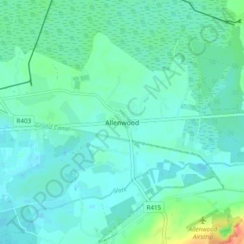
Nom : Carte topographique Allenwood, altitude, relief.
Altitude moyenne : 82 m
Altitude minimum : 73 m
Altitude maximum : 118 m
Autres cartes topographiques
Cliquez sur une carte pour visualiser sa topographie, son altitude et son relief.
Grand Canal - Barrow Line
Ireland > County Kildare > Athy
Grand Canal - Barrow Line, Athy, Athy Urban West ED, The Municipal District of Athy, County Kildare, Leinster, R14 EH50, Ireland
Altitude moyenne : 60 m
Newbridge
Newbridge, The Municipal District of Kildare — Newbridge, County Kildare, Leinster, Ireland
Altitude moyenne : 95 m
Sallins
Sallins, The Municipal District of Naas, County Kildare, Leinster, Ireland
Altitude moyenne : 81 m
Ballysax
Ballysax, The Municipal District of Kildare — Newbridge, County Kildare, Leinster, Ireland
Altitude moyenne : 107 m
Kilkea Upper
Kilkea Upper, Kilkea ED, The Municipal District of Athy, County Kildare, Leinster, Ireland
Altitude moyenne : 82 m
Carbury
Carbury, The Municipal District of Clane — Maynooth, County Kildare, Leinster, W91 K763, Ireland
Altitude moyenne : 90 m
Castledermot
Castledermot, Abbeylands, Castledermot ED, The Municipal District of Athy, County Kildare, Leinster, Ireland
Altitude moyenne : 83 m
Clane
Clane, Alexandra Walk, Clane ED, The Municipal District of Clane — Maynooth, County Kildare, Leinster, Ireland
Altitude moyenne : 70 m
The Municipal District of Athy
The Municipal District of Athy, County Kildare, Leinster, Ireland
Altitude moyenne : 101 m
Straffan
Ireland > County Kildare > Straffan
Straffan, The Municipal District of Clane — Maynooth, County Kildare, Leinster, W23 V628, Ireland
Altitude moyenne : 65 m
Athy
Athy, Athy Urban East ED, The Municipal District of Athy, County Kildare, Leinster, R14 XD30, Ireland
Altitude moyenne : 61 m
The Municipal District of Clane — Maynooth
The Municipal District of Clane — Maynooth, County Kildare, Leinster, Ireland
Altitude moyenne : 86 m
Rathangan
Ireland > County Kildare > Rathangan
Rathangan, County Kildare, Leinster, Ireland
Altitude moyenne : 76 m
Ballyteague Bog
Ballyteague Bog, Rathernan ED, The Municipal District of Kildare — Newbridge, County Kildare, Leinster, Ireland
Altitude moyenne : 77 m
Clane
Ireland > County Kildare > Clane
Clane, The Municipal District of Clane — Maynooth, County Kildare, Leinster, W91 X253, Ireland
Altitude moyenne : 78 m
Leixlip
Leixlip, The Municipal District of Celbridge — Leixlip, County Kildare, Leinster, Ireland
Altitude moyenne : 53 m
The Municipal District of Kildare — Newbridge
The Municipal District of Kildare — Newbridge, County Kildare, Leinster, Ireland
Altitude moyenne : 93 m
The Municipal District of Naas
The Municipal District of Naas, County Kildare, Leinster, Ireland
Altitude moyenne : 152 m
Castledermot
Ireland > County Kildare > Castledermot
Castledermot, The Municipal District of Athy, County Kildare, Leinster, Ireland
Altitude moyenne : 94 m