
Faire un don
Équipez-vous pour votre prochaine aventure :
En tant que Partenaire Amazon, ce site perçoit une commission sur les achats éligibles sans surcoût pour vous.
Carte topographique Kapsi
Cliquez sur la carte pour afficher l’altitude.
Faire un don
Équipez-vous pour votre prochaine aventure :
En tant que Partenaire Amazon, ce site perçoit une commission sur les achats éligibles sans surcoût pour vous.
Kapsi
Geographically, it lies in the northern lowlands of the Bastar plateau and is a part of the historical Dandakaranya region. The elevation of the village ranges from 310 m (1,020 ft) to 330 m (1,080 ft) above sea level. The Devda ravine, a tributary of Kotri river, meanders through the heart of the village and serves as its lifeline. The region primarily features fertile lateritic soil, which is well-suited to agriculture due to its fine texture and darker hues. With its dense green cover, undulating terrain, hillocks, and stream courses, the region harbours habitats for diverse flora and fauna.
Faire un don
Équipez-vous pour votre prochaine aventure :
En tant que Partenaire Amazon, ce site perçoit une commission sur les achats éligibles sans surcoût pour vous.
À propos de cette carte
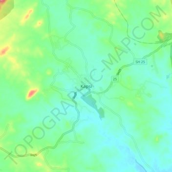
Nom : Carte topographique Kapsi, altitude, relief.
Altitude moyenne : 325 m
Altitude minimum : 301 m
Altitude maximum : 399 m
Faire un don
Équipez-vous pour votre prochaine aventure :
En tant que Partenaire Amazon, ce site perçoit une commission sur les achats éligibles sans surcoût pour vous.