
Carte topographique Alice Springs
Cliquez sur la carte pour afficher l’altitude.
Alice Springs
Temperatures in Alice Springs vary widely, and rainfall can vary quite dramatically from year to year. In summer, the average maximum temperature is in the mid-30s, whereas in winter the average minimum temperature can be 5.5 °C (41.9 °F), with an average of 12.4 nights below freezing every year, providing frost. The elevation of the town is about 545 metres (1,788 feet), which contributes to the cool nights in winter. The highest temperature on record is 47.5 °C (117.5 °F) first recorded on 24 December 1891, whilst the record low is −7.5 °C (18.5 °F), recorded on 17 July 1976. This is also the lowest temperature recorded in the Northern Territory.
À propos de cette carte
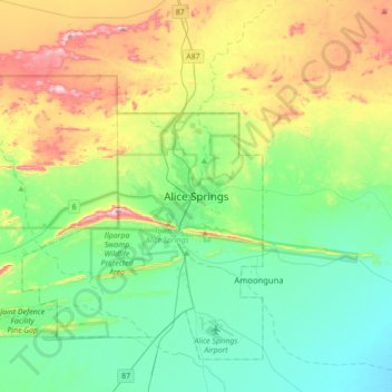
Nom : Carte topographique Alice Springs, altitude, relief.
Altitude moyenne : 631 m
Altitude minimum : 505 m
Altitude maximum : 934 m