
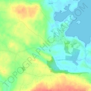
Carte topographique Killala
Carte interactive
Cliquez sur la carte pour afficher l’altitude.
À propos de cette carte
Nom : Carte topographique Killala, altitude, relief.
Altitude moyenne : 21 m
Altitude minimum : -1 m
Altitude maximum : 52 m
The Roman Catholic Diocese of Killala (Alladenis in Latin) is one of the five suffragan sees of the ecclesiastical Province of Tuam, comprising the north-western part of the County Mayo with the Barony of Tireragh in the County Sligo. In all there are 22 parishes, some of which, bordering on the Atlantic Ocean, consist mostly of wild moorland, sparsely inhabited. Lewis's Topographical Dictionary sets down the length of the diocese as 45 miles (72 km), the breadth 21 mi (34 km), and the estimated superficies as 314,300 acres (1,272 km2) – of which 43,100 acres (174 km2) are in County Sligo and 271,200 acres (1,098 km2) in County Mayo.
Autres cartes topographiques
Cliquez sur une carte pour visualiser sa topographie, son altitude et son relief.
Illanoona
Illanoona, Corraun Achill ED, Westport-Belmullet Municipal District, County Mayo, Connacht, Ireland
Altitude moyenne : 20 m
Inishowen
Inishowen, Neale Electoral Division, Claremorris-Swinford Municipal District, County Mayo, Connacht, Ireland
Altitude moyenne : 18 m
Tawnyinah Upper
Tawnyinah Upper, Kilbeagh ED, Claremorris-Swinford Municipal District, County Mayo, Connacht, Ireland
Altitude moyenne : 121 m
Saleen
Saleen, Hollymount Electoral Division, Claremorris-Swinford Municipal District, County Mayo, Connacht, Ireland
Altitude moyenne : 34 m
Ballindine
Ballindine, Claremorris-Swinford Municipal District, County Mayo, Connacht, Ireland
Altitude moyenne : 62 m
Knock
Knock, Claremorris-Swinford Municipal District, County Mayo, Connacht, F12 KF89, Ireland
Altitude moyenne : 94 m
Ballina Municipal District
Ballina Municipal District, County Mayo, Connacht, Ireland
Altitude moyenne : 74 m
Castlebar
Castlebar, Castlebar Municipal District, County Mayo, Connacht, Ireland
Altitude moyenne : 44 m
Westport-Belmullet Municipal District
Westport-Belmullet Municipal District, County Mayo, Connacht, Ireland, Croaghaun
Altitude moyenne : 275 m
Cloghans
Cloghans, Carrowmore ED, Ballina Municipal District, County Mayo, Connacht, Ireland
Altitude moyenne : 14 m
Oory
Oory, Cloghermore Electoral Division, Claremorris-Swinford Municipal District, County Mayo, Connacht, Ireland
Altitude moyenne : 47 m
Claremorris-Swinford Municipal District
Claremorris-Swinford Municipal District, County Mayo, Connacht, Ireland
Altitude moyenne : 69 m
Clare Island
Clare Island, Westport-Belmullet Municipal District, County Mayo, Connacht, Ireland
Altitude moyenne : 29 m
Garrankeel
Garrankeel, Ballina Rural ED, Ballina Municipal District, County Mayo, Connacht, Ireland
Altitude moyenne : 20 m
Achill Island
Achill Island, County Mayo, Connacht, F28 X018, Ireland
Altitude moyenne : 42 m
Westport-Belmullet Municipal District
Westport-Belmullet Municipal District, County Mayo, Connacht, Ireland
Altitude moyenne : 62 m
Mayo
Mayo, Claremorris-Swinford Municipal District, County Mayo, Connacht, F12 E7W7, Ireland
Altitude moyenne : 53 m
Mount Eagle
Mount Eagle, Westport-Belmullet Municipal District, County Mayo, Connacht, Ireland
Altitude moyenne : 274 m
Ballinglen
Ballinglen, Ballycastle ED, Ballina Municipal District, County Mayo, Connacht, Ireland
Altitude moyenne : 117 m
Castlebar
Ireland > County Mayo > Castlebar
Castlebar, Castlebar Municipal District, County Mayo, Connacht, F23 DP02, Ireland
Altitude moyenne : 56 m
Ballinrobe
Ireland > County Mayo > Ballinrobe
Ballinrobe, Claremorris-Swinford Municipal District, County Mayo, Connacht, F31 Y865, Ireland
Altitude moyenne : 32 m
Shrule
Ireland > County Mayo > Shrule
Shrule, Claremorris-Swinford Municipal District, County Mayo, Connacht, Ireland
Altitude moyenne : 35 m
Swineford
Swineford, Swineford Electoral Division, Claremorris-Swinford Municipal District, County Mayo, Connacht, Ireland
Altitude moyenne : 65 m
Croagh Patrick
Croagh Patrick, Westport-Belmullet Municipal District, County Mayo, Connacht, Ireland
Altitude moyenne : 314 m
Westport
Ireland > County Mayo > Westport
Westport, Westport-Belmullet Municipal District, County Mayo, Connacht, F28 RD39, Ireland
Altitude moyenne : 40 m
Claremorris
Ireland > County Mayo > Claremorris
Claremorris, Claremorris-Swinford Municipal District, County Mayo, Connacht, F12 RY11, Ireland
Altitude moyenne : 67 m
Belmullet
Ireland > County Mayo > Belmullet
Belmullet, Westport-Belmullet Municipal District, County Mayo, Connacht, Ireland
Altitude moyenne : 14 m
Lecarrow
Lecarrow, Knock North Electoral Division, Claremorris-Swinford Municipal District, County Mayo, Connacht, Ireland
Altitude moyenne : 83 m
Kilmovee
Ireland > County Mayo > Kilmovee
Kilmovee, Claremorris-Swinford Municipal District, County Mayo, Connacht, Ireland
Altitude moyenne : 104 m
Carrowmore
Carrowmore, Cloghermore Electoral Division, Claremorris-Swinford Municipal District, County Mayo, Connacht, Ireland
Altitude moyenne : 48 m
Ballindine
Ireland > County Mayo > Ballindine
Ballindine, Claremorris-Swinford Municipal District, County Mayo, Connacht, Ireland
Altitude moyenne : 61 m
Milford Demesne
Milford Demesne, Dalgan Electoral Division, Claremorris-Swinford Municipal District, County Mayo, Connacht, Ireland
Altitude moyenne : 36 m
Newport
Ireland > County Mayo > Newport
Newport, Westport-Belmullet Municipal District, County Mayo, Connacht, Ireland
Altitude moyenne : 23 m
Drumbaun
Drumbaun, Ballyhaunis ED, Claremorris-Swinford Municipal District, County Mayo, Connacht, Ireland
Altitude moyenne : 77 m
Brickeens
Brickeens, Culnacleha Electoral Division, Claremorris-Swinford Municipal District, County Mayo, Connacht, Ireland
Altitude moyenne : 71 m
Derrypark
Derrypark, Owenbrin Electoral Division, Castlebar Municipal District, County Mayo, Connacht, Ireland
Altitude moyenne : 46 m
Derrymore
Derrymore, Coonard Electoral Division, Claremorris-Swinford Municipal District, County Mayo, Connacht, Ireland
Altitude moyenne : 45 m
Bangor
Ireland > County Mayo > Bangor
Bangor, Westport-Belmullet Municipal District, County Mayo, Connacht, Ireland
Altitude moyenne : 71 m
Benmore
Benmore, Westport-Belmullet Municipal District, County Mayo, Connacht, Ireland
Altitude moyenne : 119 m
Castlehill
Castlehill, Crossmolina South ED, Ballina Municipal District, County Mayo, Connacht, Ireland
Altitude moyenne : 19 m
Glenavenew
Glenavenew, Addergoole ED, Castlebar Municipal District, County Mayo, Connacht, Ireland
Altitude moyenne : 82 m
Knock
Ireland > County Mayo > Knock
Knock, Claremorris-Swinford Municipal District, County Mayo, Connacht, F12KF89, Ireland
Altitude moyenne : 87 m