
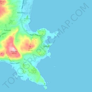
Carte topographique Lindos
Carte interactive
Cliquez sur la carte pour afficher l’altitude.
À propos de cette carte
Nom : Carte topographique Lindos, altitude, relief.
Altitude moyenne : 47 m
Altitude minimum : 0 m
Altitude maximum : 450 m
Autres cartes topographiques
Cliquez sur une carte pour visualiser sa topographie, son altitude et son relief.
Kolymbia
Griechenland > Ägäis > Regionalbezirk Rhodos
Kolymbia, Δήμος Ρόδου, Regionalbezirk Rhodos, Region Südliche Ägäis, Ägäis, 851 02, Griechenland
Altitude moyenne : 31 m
Αρχίπολη
Griechenland > Ägäis > Regionalbezirk Rhodos
Αρχίπολη, Δήμος Ρόδου, Regionalbezirk Rhodos, Region Südliche Ägäis, Ägäis, 851 06, Griechenland
Altitude moyenne : 256 m
Salakos
Griechenland > Ägäis > Regionalbezirk Rhodos > Salakos
Salakos, Δήμος Ρόδου, Regionalbezirk Rhodos, Region Südliche Ägäis, Ägäis, 85106, Griechenland
Altitude moyenne : 287 m
Pefki
Griechenland > Ägäis > Regionalbezirk Rhodos
Pefki, Δήμος Ρόδου, Regionalbezirk Rhodos, Region Südliche Ägäis, Ägäis, 851 07, Griechenland
Altitude moyenne : 42 m
Ialysos
Griechenland > Ägäis > Regionalbezirk Rhodos > Ialysos
Ialysos, Δήμος Ρόδου, Regionalbezirk Rhodos, Region Südliche Ägäis, Ägäis, 85101, Griechenland
Altitude moyenne : 36 m