
Faire un don
Équipez-vous pour votre prochaine aventure :
En tant que Partenaire Amazon, ce site perçoit une commission sur les achats éligibles sans surcoût pour vous.
Carte topographique Dandenong Ranges National Park - Ferntree Gully
Cliquez sur la carte pour afficher l’altitude.
Faire un don
Équipez-vous pour votre prochaine aventure :
En tant que Partenaire Amazon, ce site perçoit une commission sur les achats éligibles sans surcoût pour vous.
Dandenong Ranges National Park - Ferntree Gully
The topography consists of a series of ridges dissected by deeply cut streams. Sheltered gullies in the south of the range are home to temperate rain forest, fern gullies and Mountain Ash forest Eucalyptus regnans, whereas the drier ridges and exposed northern slopes are covered by dry sclerophyll forest of stringybarks and box. The entire range is highly prone to bushfires, the most recent of which have been the 1983 Ash Wednesday bushfires, the 1997 Dandenong Ranges bushfires and small fires during the Black Saturday bushfires in 2009.
Faire un don
Équipez-vous pour votre prochaine aventure :
En tant que Partenaire Amazon, ce site perçoit une commission sur les achats éligibles sans surcoût pour vous.
À propos de cette carte
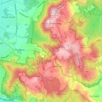
Nom : Carte topographique Dandenong Ranges National Park - Ferntree Gully, altitude, relief.
Altitude moyenne : 345 m
Altitude minimum : 67 m
Altitude maximum : 621 m
Faire un don
Équipez-vous pour votre prochaine aventure :
En tant que Partenaire Amazon, ce site perçoit une commission sur les achats éligibles sans surcoût pour vous.