
Carte topographique Shahin Shahr
Carte interactive
Cliquez sur la carte pour afficher l’altitude.
À propos de cette carte
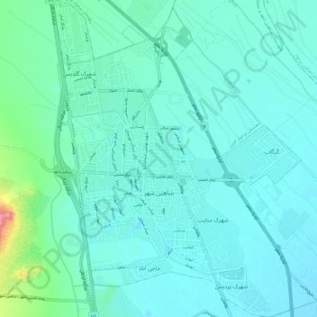
Nom : Carte topographique Shahin Shahr, altitude, relief.
Altitude moyenne : 1’601 m
Altitude minimum : 1’583 m
Altitude maximum : 1’709 m
Autres cartes topographiques
Cliquez sur une carte pour visualiser sa topographie, son altitude et son relief.
دهستان برخوار غربی
Iran > Isfahan Province > Shahin Shahr and Meymeh County
دهستان برخوار غربی, Shahin Shahr and Meymeh Central District, Shahin Shahr and Meymeh County, Isfahan Province, Iran
Altitude moyenne : 1’806 m