
Carte topographique Blanchard
Carte interactive
Cliquez sur la carte pour afficher l’altitude.
À propos de cette carte
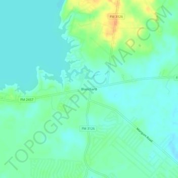
Nom : Carte topographique Blanchard, altitude, relief.
Lieu : Blanchard, Polk County, Texas, United States (30.71686 -95.07549 30.75686 -95.03549)
Altitude moyenne : 47 m
Altitude minimum : 37 m
Altitude maximum : 71 m
Autres cartes topographiques
Cliquez sur une carte pour visualiser sa topographie, son altitude et son relief.
Livingston
United States > Texas > Polk County
Livingston, Polk County, Texas, United States
Altitude moyenne : 63 m
Lake Livingston State Park
United States > Texas > Polk County
Lake Livingston State Park, Polk County, Texas, United States
Altitude moyenne : 43 m
Lake Livingston
United States > Texas > Polk County
Lake Livingston, Polk County, Texas, United States
Altitude moyenne : 66 m
Segno
United States > Texas > Polk County
Segno, Polk County, Texas, United States
Altitude moyenne : 60 m
West Livingston
United States > Texas > Polk County
West Livingston, Polk County, Texas, 77351, United States
Altitude moyenne : 42 m
Corrigan
United States > Texas > Polk County
Corrigan, Polk County, Texas, 75939, United States
Altitude moyenne : 76 m
Tobacco Patch
United States > Texas > Polk County > Tobacco Patch
Tobacco Patch, Polk County, Texas, United States
Altitude moyenne : 43 m
Asia
United States > Texas > Polk County > Asia
Asia, Polk County, Texas, 75939, United States
Altitude moyenne : 80 m
Dallardsville
United States > Texas > Polk County > Dallardsville
Dallardsville, Polk County, Texas, 77332, United States
Altitude moyenne : 76 m
Goodrich
United States > Texas > Polk County
Goodrich, Polk County, Texas, United States
Altitude moyenne : 38 m
Seven Oaks
United States > Texas > Polk County
Seven Oaks, Polk County, Texas, United States
Altitude moyenne : 68 m
Onalaska
United States > Texas > Polk County
Onalaska, Polk County, Texas, 77360, United States
Altitude moyenne : 49 m