
Carte topographique Bear Lake
Carte interactive
Cliquez sur la carte pour afficher l’altitude.
À propos de cette carte
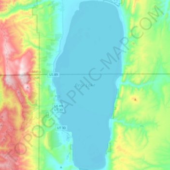
Nom : Carte topographique Bear Lake, altitude, relief.
Lieu : Bear Lake, Garden City, Rich County, Utah, United States (41.84591 -111.41042 42.12034 -111.25602)
Altitude moyenne : 2’038 m
Altitude minimum : 1’801 m
Altitude maximum : 2’817 m
Formed in a half graben valley straddling the Idaho-Utah border, the lake has an approximate area of 109 square miles (280 km2) and sits at an elevation of 5,924 feet (1,806 m) along the northeast side of the Wasatch Range and the east side of the Bear River Mountains.
Autres cartes topographiques
Cliquez sur une carte pour visualiser sa topographie, son altitude et son relief.
Garden
United States > Utah > Rich County > Garden City
Garden, Garden City, Rich County, Utah, United States
Altitude moyenne : 2’100 m