
Carte topographique Sahel
Carte interactive
Cliquez sur la carte pour afficher l’altitude.
À propos de cette carte
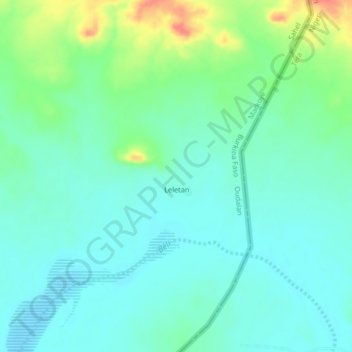
Nom : Carte topographique Sahel, altitude, relief.
Lieu : Sahel, Markoye, Oudalan, Sahel, Burkina Faso (13.89555 -0.77157 15.89555 1.22843)
Altitude moyenne : 279 m
Altitude minimum : 204 m
Altitude maximum : 492 m
The topography of the Sahel is mainly flat; most of the region lies between 200 and 400 meters (660 and 1,310 ft) in elevation. Several isolated plateaus and mountain ranges rise from the Sahel, but are designated as separate ecoregions because their flora and fauna are distinct from the surrounding lowlands. Annual rainfall varies from around 100–200 mm (4–8 in) in the north of the Sahel to around 700–1,000 mm (28–39 in) in the south.
Autres cartes topographiques
Cliquez sur une carte pour visualiser sa topographie, son altitude et son relief.
Fabédougou
Fabédougou, Bérégadougou, Comoé, Waterfalls, Burkina Faso
Altitude moyenne : 333 m
Dômes de Fabedougou
Dômes de Fabedougou, Bérégadougou, Comoé, Waterfalls, Burkina Faso
Altitude moyenne : 333 m
Soubakaniédougou
Soubakaniédougou, Comoé, Waterfalls, Burkina Faso
Altitude moyenne : 309 m
Dédougou
Dédougou, Mouhoun, Boucle du Mouhoun, Burkina Faso
Altitude moyenne : 298 m