
Carte topographique Almora
Cliquez sur la carte pour afficher l’altitude.
Almora
Almora is located at 29°35′50″N 79°39′33″E / 29.5971°N 79.6591°E / 29.5971; 79.6591 in Almora district in Uttarakhand. Almora is situated 365 km north-east the national capital New Delhi and 415 km south-east the state capital Dehradun. It lies in the revenue Division Kumaon and is located 63 km north of Nainital, the administrative headquarters of Kumaon. It has an average elevation of 1,861 m (6,106 ft) above mean Sea Level.
À propos de cette carte
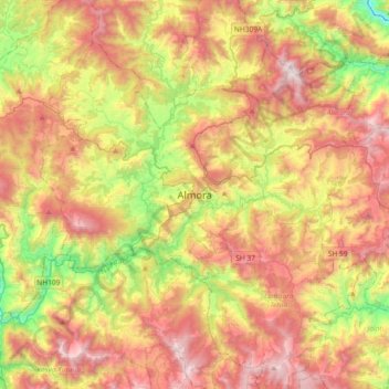
Nom : Carte topographique Almora, altitude, relief.
Lieu : Almora, Uttarakhand, 263600, India (29.44168 79.50338 29.76168 79.82338)
Altitude moyenne : 1’557 m
Altitude minimum : 762 m
Altitude maximum : 2’383 m