

Carte topographique Odanthurai
Cliquez sur la carte pour afficher l’altitude.
À propos de cette carte
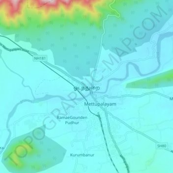
Nom : Carte topographique Odanthurai, altitude, relief.
Altitude moyenne : 365 m
Altitude minimum : 282 m
Altitude maximum : 1’056 m
Autres cartes topographiques
Cliquez sur une carte pour visualiser sa topographie, son altitude et son relief.
Mettupalayam
India > Tamil Nadu > Mettupalayam
Mettupalayam is located at 11°18′00″N 76°57′00″E / 11.3000°N 76.9500°E / 11.3000; 76.9500. It has an average elevation of 314 metres (1033 feet). Mettupalayam is situated on the bank of Bhavani River at the foot of the Nilgiri mountains.
Altitude moyenne : 321 m




Mettupalayam
India > Tamil Nadu > Mettupalayam
Mettupalayam is located at 11°18′20″N 76°56′06″E / 11.3056°N 76.9350°E / 11.3056; 76.9350. It has an average elevation of 314 m (1,030 ft). Mettupalayam is situated on the bank of Bhavani River at the foot of the Nilgiri mountains.
Altitude moyenne : 321 m
Bhavani
India > Tamil Nadu > Mettupalayam
The Bhavani is a 234 km (145 mi) long perennial river fed by monsoons. The river originates at an altitude of 2,634 m (8,642 ft) in the Billimala range of the Nilgiris in the Western Ghats in Tamil Nadu. It flows westwards towards the Silent Valley National Park in Kerala, before later turning eastwards and…
Altitude moyenne : 923 m
Mettupalayam
India > Tamil Nadu > Mettupalayam
Mettupalayam is located at 11°18′20″N 76°56′06″E / 11.3056°N 76.9350°E / 11.3056; 76.9350. It has an average elevation of 314 m (1,030 ft). Mettupalayam is situated on the bank of Bhavani River at the foot of the Nilgiri mountains.
Altitude moyenne : 321 m
